

Introduction
Shoal Bay – “Where sunshine spends the winter”
Port Stephens Heads – “a tonic for the eyes”
So reported the The Newcastle Sun 24 December 1948, page 1, as it noted that ‘up at Port Stephens they are becoming scenic-slogan-conscious.’
Port Stephens is renowned for its beauty, its geography and its history.
The Newcastle Morning Herald and Miners’ Advocate, 6 February 1954, published an article reflecting all three aspects, from a view from the summit of Mount Tomaree.
The writer reflected on:
- how Aboriginal people may have viewed the landscape;
- natural features of the Port Stephens area including both the islands inside the Bay and those offshore; and
- history of the townships of Port Stephens, particularly the then most recent developments as the area was recovering post-World War Two.
Reflection on the Port Stephens Natural and Urban Environments
The full newspaper article is published as below:
‘Australia has retained hundreds of aboriginal names for towns and landmarks. Some are strange, many soft and euphonious, while they all have a meaning that invariably depicts some part of the district, or some outstanding tree, landmark or waterhole.
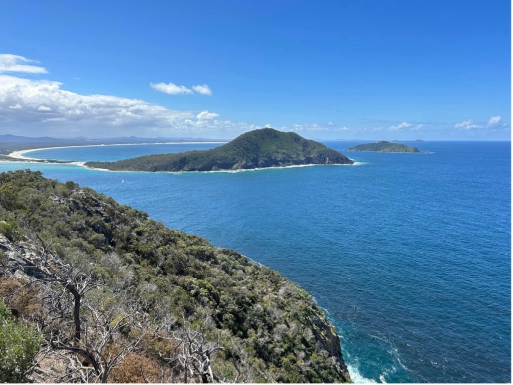
The two rugged and mighty peaks guarding the entrance to Port Stephens must surely have stirred the natives’ imagination when they gave North Head the odd-sounding name of Yacaaba, and its slightly lower but more prominent southern counterpart the soft, mysterious sounding Tomaree. To some it may seem a pity that no records remain to tell us the meaning of these strange words. To those of us who have climbed to Tomaree’s shrub-covered, wind-swept peak, there is little doubt that its meaning must surely be attributed to the beauty of the scene spread out below.
Port Stephens headlands – Yacabba (left) and Tomaree (right) [Author Photo]
The Australian aboriginal had a highly developed power of observation and a long memory for things he liked. Even if he did not appreciate beauty as we see it, the magnificence of what he saw from Tomaree’s peak no doubt so impressed him that this word could well have been his expression of satisfaction, his exclamation of delight: Too – meree! When he watched the summer sun rise golden from the horizon over the Pacific Ocean, he did not see as we can today, the faint outline of the mighty industrial city of Newcastle 25 miles to the south.
He would have seen Tomaree’s three neighbouring conical mountains forming a majestic backdrop to the curving sandy beaches, with frothing breakers rolling steadily in. Turning westward, the great sweep of the port cannot have changed much in general outline. Spreading over 25,000 acres, and extending 11 miles back, it is more than three miles across at the widest. Past deep channels, shallow sandbanks and countless beautiful tree-fringed bays, the waters of the port spread out like a great sheet of rippling silver in the evening sun.
To the north-west, as far as the eye can see, the Karuah River enters the inlet, and from this point start many large oyster leases extending for miles along the foreshores to Lemon Tree Passage, Tilligerry Creek, Swan Bay, and many other places. Port Stephens is famous for the excellence of its oysters and oyster farming forms one of the major industries.
Yacabba as viewed from Tomaree, showing the harbour entrance, and looking north with Broughton Island in the far distance [Author Photo]
Still looking westward from Tomeree, the long, tree-covered expanse of Soldier’s Point extends from Salamander Bay, almost meeting the small island the aborigines knew as Boandabah. The tide races past either side of this island in very deep water, but near Soldiers’ Point it falls away to a shallow calm, the favoured spots of amateur fishermen. Once there was only a handful of huts. at this picturesque spot, but now many modern and comfortable bungalows and residences line the waterfront.
Within two miles of the heads on the southern shore, fronted by a sandy beach, is the main township, of Nelson’s Bay. For very many years Nelson’s Bay was sparsely settled and a very rough and stony track served for a road which joined the settlement with Newcastle at Stockton some 30 miles away. The residents were mostly hardy fishermen, who netted the beaches for the great schools of sea mullet, bream, blackfish and other pelagic fishes. A few went out in small craft to catch deep sea fish, snapper, morwong, flathead, and many other species of edible fish – working long hours in all kinds of weather, mostly making their catches by handlines. Lobster pots were made and set out in the deep water. This, together with seine trawling and trapping rough-skinned, sharp-toothed leatherjackets, gave the townsfolk their livelihood.
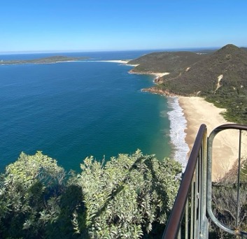
Looking south from Mount Tomaree [Author Photo]
The fame of the port and its adjacent waters soon spread. Amateur fishermen came from near and far to try the waters off Broughton Island, 10 miles northwards. Here they caught great quantities of snapper and many other deepwater fish. The sporting light-game fishermen soon found that here, too, were fighting fish such as tuna, mackerel and kingfish, worthy of their attention. The late Sir Herbert Maitland and his friend, Mr. E. P. Andreas, came regularly from Sydney to pit their skill against these fighting fish. A small band of enthusiasts from Newcastle and Maitland then discovered marlin at the doorstep of the port, and so came about the formation of the Newcastle and Port Stephens Game Fish Club. Many Australian and several world record catches have been made by its members, and the waters off Port Stephens are now considered amongst the best big game fishing areas off Australia.
Still the town of Nelson’s Bay remained unchanged till World War II brought troops by the thousand into the district. Soon bulldozers were pushing their way through the scrub and good roads appeared where earlier there had been only sandy bush tracks. After the war, fishing was taken up again, but by now boats and gear were vastly improved and things became more mechanised.
The town at last started to grow rapidly as people became aware of the good roads and attractions within comparatively easy distance of Newcastle and the Coalfields. Interest in amateur fishing was the main stimulus. Plain tent camping gear gave way to holiday homes, and caravans, guest houses and cabins developed and were soon booked out a year in advance. The beaches at Nelson’s Bay and Shoal Bay became favourites with the holiday crowds and, though lacking in surf, proved ideal for children to swim and frolic in the calm water, and sunbake on the clean white sand.
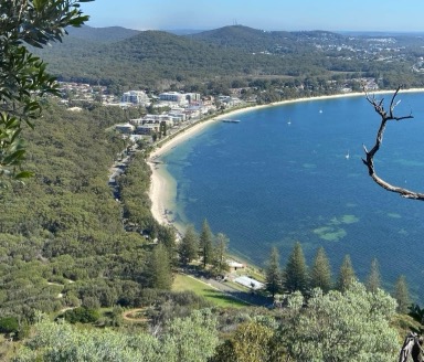
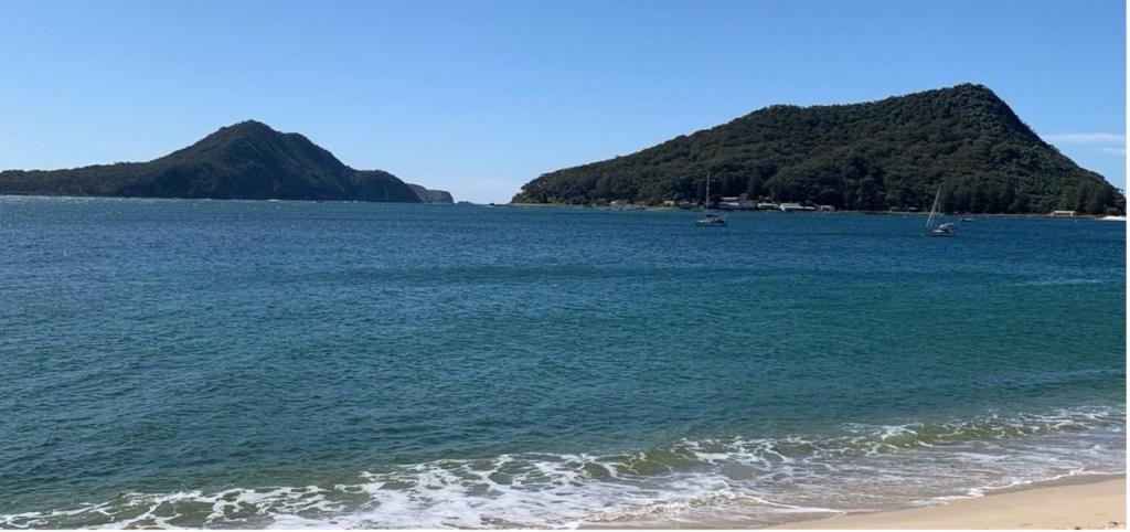
Shoal Bay as viewed from Mount Tomaree [Author Photo]
Looking down now from Tomaree, Shoal Bay curves away from the very foot of the mountain in a great, sandy tree-fringed arc, to the small lighthouse on Nelson Head. Once, only one lone launch rode at its solitary mooring out from the beach. Now more than a dozen up-to-date launches, all good seaworthy craft, cluster around the edge of the beach in front of Shoal Bay Country Club. Some are professional fishing boats, some game fishing launches, others pleasure launches, but all go out into the deep waters of the Pacific off Broughton Island in search of fish.
Far across the bay, to the north-west, the winding Myall River opens into Port Stephens at Corrie Island. For miles along these shallow shores, from Pindimar to Winda Woppa, to the township of Tea Gardens and beyond, thousands upon thousands of neatly stacked wooden stakes represent the district’s wealth in oyster culture. The Myall can be navigated up-stream by small boats, through a series of lakes, for 25 miles. Down from Bungwahl come the paddle-wheeled droghers carrying loads of hardwood and other timbers from the great, dense brushes and gullies to the mills at Winda Woppa, and for timber boats from Sydney.
Down from Tamboy come also the finest prawns in the State, to be rushed to the markets in Sydney and Melbourne. In the flat, scrub-covered bushland between the river and the sea, native flowers add their brilliance and perfume in the springtime, while many varieties of birds feed on the honey and insect life the plants attract. Creamy white flannel flowers like green-tipped stars spread in great patches over the whole bushland. Contrasting with these, pale pink eriostemon, crowea, and the darker and sweet-scented boronias make a blaze of glory everywhere. In the more swampy areas thousands of crimson bottle brushes bend their soft, hairlike blooms on slender stalks with green and silver leaves.
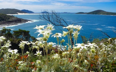
Native flannel flowers overlooking several islands that lie off Port Stephens [Author Photo]
A mile offshore from rugged Yacaaba, guarding the entrance to the port, lie two large islands and one small one. The aboriginal possibly never saw the heads from out at sea, for it is said he did not have the art of canoe making. So, there remains but one name for the centre island, which was called Boondelbah. The other two are known simply as Little Island, as a contrast to Boondelbah, or Big Island and Cabbage Tree Island. Cabbage Tree Island is covered in dense scrub, fig trees, and cabbage tree palms. Strangely the other two are bare of flora apart from course rushes and a few hardy low-growing shrubs.
Cabbage Tree Island is the only known nesting place in the world of a species of sea bird discovered more than 100 years ago by John Gould, the ornithologist. The species still occupy the island at certain times of the year. It bears the name Gould’s Petrel. The birds come in from miles to sea and make their landfall after dark, crashing through the thick canopy of palm leaves to alight with uncanny accuracy near the nesting sites they have chosen under the great boulders covering the steep hillside. Nemesis awaits the birds who come home before dark: the fierce peregrine falcon, credited with speed of more than 200 miles an hour, perches, ready to swoop on them.
And so back to the lookout on South Head, which has changed but little in thousands of years. The black north-easters that scream like Harpies through the heads in summer, the cold grey southerlies lashing the rocks with great crashing seas, rainstorms, fogs, westerlies, and bright sunny days, the aboriginal saw them all – and wondered at nature’s moods.’
Postscript
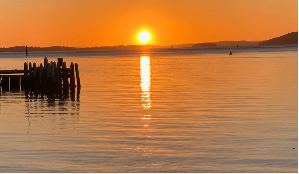
Sunset over the waters of Port Stephens – looking west from Little Beach [Author photo]
The following papers at these links on the website relate early travel excursions in the Port Stephens region:
History of Tourism Promotion at Port Stephens
The Lakes Travel Route to Mid-North Coast
A four-day excursion to Port Stephens – Christmas 1906
A personal tour of Port Stephens – 1914
Excursion from Newcastle to Port Stephens by sea
A journey from Port Stephens up the Myall River to Forster – 1908
Researched and compiled by Kevin McGuinness
March 2025
