
Introduction
Governor Lachlan Macquarie arrived in Sydney on 28 December 1809 and was sworn in as Governor of New South Wales on 1 January 1810.
He made several tours of discovery of the Colony from Sydney. In November 1810, the first was to inspect the countryside and towns on the outskirts of Sydney, including Richmond, Windsor, Wilberforce, Castlereagh and Pitt Town.
In December 1811, Macquarie undertook his second tour of areas further afield. Aboard the brig Lady Nelson, he sailed firstly to Van Diemen’s Land where he spent a month inspecting areas such as Hobart Town and Port Dalrymple.
On the return journey before resuming his duties in Sydney, Macquarie and his party sailed past Port Jackson in the Lady Nelson north to Port Stephens and Newcastle, with a view to further colonial expansion.
From his journal, we learn that Governor Macquarie was impressed by the size of Port Stephens and the safe anchorage it offered to vessels. He was not however impressed by the surrounding countryside as being suitable for farming and grazing.
While at Port Stephens, Macquarie celebrated the second anniversary of his appointment as Governor of the Colony.
He formally named various geographical places, but these colonial names do not remain in use today.
This paper documents Macquarie’s two-day visit to Port Stephens where he arrived in the waters of the Bay on 31 December 1811.

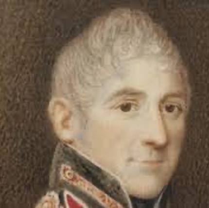
Governor Lachlan Macquarie [State Library of NSW]
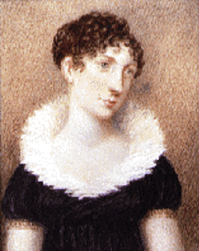
Elizabeth Macquarie (nee Campbell) [State Library of NSW]
Extracts from Governor Macquarie’s Journal of his Visit to Port Stephens
The extracts from his journal, as cited, are found in the Lachlan & Elizabeth Macquarie Archive (LEMA) which is an initiative of Macquarie University Library, in partnership with the State Library of NSW, State Records NSW, the National Library of Scotland, the Historic Houses Trust of NSW, the National Library of Australia, and the National Museum of Australia.
The journal entries as relating to the Governor’s visit to Port Stephens begin as follows:
30 December 1811
‘At noon this day [Monday] we were in the Latitude of Port Jackson, namely 33. 53’ South, and within sight of Port Jackson Heads, having thus only gained 75 miles of real distance in 18 Hours last past; that being the distance between Jarvis’s Bay and Port Jackson, the former of which places we were abreast of at 6 o’clock last night; whilst by our Log we ran no less than 124 miles in these 18 hours; consequently we lost 49 miles by the current setting to the southward, notwithstanding there was a strong gale of wind with a high following sea driving us on at the rate of 7 miles an hour on an average all yesterday and last night.
Intending always to visit Port Stephens and the settlement of Newcastle in Hunter’s River, previous to my return to Sydney, this coming within the scope of my present tour of inspection; I gave orders to Mr. Overand the Commander of the ‘Lady Nelson’ to steer direct for Port Stephens, which is about eighty miles to the northward of Port Jackson, in order to afford me an opportunity of examining that harbour — which is reported to me to be not only very capacious but also a very safe and commodious one for shipping easy of access in all winds, and well supplied with fresh water.
At 7 p.m. we were in sight and within ten miles of the Point to the Northward of Hunter’s River and on which is the settlement of Newcastle. The wind still continues fair and blowing a fresh breeze at southwest but a strong current against us.’
31 December 1811
‘At 2 o’clock this morning, having arrived off Port Stephens, we hove-to till Daylight, in order to see our way in.
At 6 a.m. made sail towards the land, then about 5 miles distant from us, the morning being rainy & hazy. At 1/4 past 7 a.m. we passed through the entrance into Port Stephens formed by the North & South Heads, two remarkable high peaked hills, resembling two Islands at a distance; the breadth between those Heads being about a mile and a half – having a bar across the Channel the whole way – but perfectly safe for ships of the largest burthen – having no less than 41/2 fathoms water in the shoaliest part of it even at low water. At half past 7 a.m. we anchored in Port Stephens – in the first Bason [present day Shoal Bay] – in 51/2 fathom water, very fine anchorage and protected from all winds.
At 8 a.m. we saw some Natives on shore on the south side of the bay, and four of them came off in their canoes (there being two in each) soon afterwards to the vessel, came on board, eat some biscuit, and seemed void of any fear or apprehension of us. They were stout, tall and well-made people.
At 10 a.m. Mrs. Macquarie and myself, accompanied by the gentlemen of our family and Mr. Overand, made an excursion to the north side of the Bay, landed and walked across a narrow neck of land [present day Jimmys Beach], not more than 200 yards broad, to a large capacious bay running East & West (parallel with Port Stephens) with a fine Island at the mouth of it [present day Corrie Island], which serves to shelter vessels that might anchor in this bay from all winds. I have named this fine capacious bay, Clarence Bay, in honour of His R.H. the Duke of Clarence, and the Island at the Entrance of it I have named Elizabeth Island after Mrs Macquarie. I have also named the Bay formed by the South Head of Port Stephens and Point Stephens, on the South side of the Entrance of the former, York-Bay in honour of H.R.H. the Duke of York; and the Island at the Entrance of Port Stephens I have named Inch Kenneth [present day Boondelbah Isand], from its resemblance to the Island of Inch Kenneth in Argyleshire.
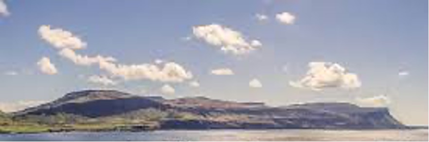
Inch Kenneth island, Argyleshire
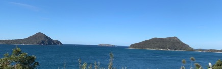
Boondelbah Island, Port Stephens – [Author Photo 2022]
After walking for about an hour on shore we returned on board again; but just as we had set out in our boat from the beach, a single Native came running after us, holding up a fish in his hand, which he seemed disposed to give us. We put back to the shore to speak to him; he approached towards the boat with great caution, and apparently under fear of being molested. He however ventured near enough to the boat to hand his Fish to Mrs. Macquarie, who gave him a piece of tobacco in return, with which he seemed much pleased, but would by no means either come into the boat or shake hands with any of us. After the boat had put off from the beach he strutted and walked about on it in a very conceited fantastical manner, dancing and capering and making a number of signs which we did not understand.
The outer or first bason of Port Stephens, in which we are now lying at anchor, is about three miles in breadth from the North to the South side of the Bay, and about ten miles in depth, from the entrance to an Island due west from it [present day Middle Island], which Island is centrically situated between two points; the three forming the boundary line between the Outer and inner basons of Port Stephens. This island I have named Meredith Island in honour of Mrs Macquarie’s esteemed friend Miss Meredith. The land, as far as we can see, round this outer bason, is well wooded, being a succession of moderately high Hills, but a poor barren soil. The harbour however is good, safe, and capacious, and affords shelter for vessels from all winds. There is also plenty of good fresh water to be procured on shore in lagoons and springs contiguous to the beach on the south side of the Bay, and very near our present anchorage off the Nelson’s Head.
On the turn of the tide off flood, we weighed anchor and stood up the Harbour, at 1/4 before 7 p.m., and at 9 p.m. we anchored again within a quarter of a mile of Meredith Island, which is nine miles from our last anchorage at the Nelson’s Head. The ‘Lady Nelson’ is the first vessel that ever came up this far.’
1 January 1812
‘This day two years, I assumed the Government of the Territory of New South Wales and its Dependent Settlements; the anniversary of which I am this day to celebrate in Port Stephens.
Wishing to explore the inner or second bason of this fine Harbour, I ordered the ‘Lady Nelson’ to proceed up it as far as she could do so with safety on the turning of the tide of flood this morning. She weighed anchor accordingly at 5 a.m.; but the wind being ahead she made very little progress, and therefore dropped anchor again about half a mile above Meredith Island in the inner bason, at 7 a.m. I consequently resolved on exploring this noble extensive bason in the ship’s boat, and with this view we breakfasted immediately after the ‘Lady Nelson’ came to anchor.
At 1/4 after 8 a.m. Mrs. Macquarie. and myself, accompanied by the gentlemen of our party and Mr. Overand, set out in the boat from the ‘Lady Nelson’, with the tide of flood in our favour. We crossed over many shoals of sand and mud, and after a row of two hours, reached the bottom of this inner Harbour, about twelve miles distant from Meredith Island. Here we expected to fall in with a large freshwater river, which was reported to me to fall into this bay at the head of it. We did not here however find any such river; but in nearly a due west direction from the Heads & Meredith Island, we discovered a saltwater creek of considerable size and pursued the winding serpentine course of it for four miles into the interior of the country without discovering any good land or fresh water.
We therefore returned back, the same way we went, to explore other parts of this inner bason; naming this salt water creek Meehan Creek. We directed our course north westerly, along the head of the bay, to look for the river; and observing an extensive opening or Inlet run in a northerly direction, we proceeded into it, and found on a nearer approach, that it was the mouth of a large river [present day Karuah River]. We rowed up this river four miles to a point of land from whence we could observe that it divides itself into two branches: the one running in a westerly direction and the other in a North Easterly direction. As far as to the point of land we halted at the river was about a quarter of a mile broad, but the water quite salt. The Banks of the River on both sides are hilly, but no good land was to be seen, nor was any cedar or other good useful timber growing on them.
Whilst our lunch was preparing, Mrs. Macquarie and myself walked up to the top of a high steep hill, about half a mile from the bottom to the top. From the summit of this hill we had a very fine extensive prospect of the principal branch of the river, and the interior of the country in every direction for 25 miles. No Plains, or good land, were to be seen in any direction, and the country here appears wild and sterile; being neither fit for agriculture nor for grazing farms, as far as we can judge from what we have seen.
On returning to the foot of the hill where we had landed and sitting down to our lunch, I christened this River the Clyde after the River of the same name in Scotland. Having taken our Lunch and rested here for a couple of hours, we set out at 1/4 before 5 p.m. to return to the ‘Lady Nelson’, now about 15 or 16 miles distant from us. The tide of ebb was now nearly spent and the wind being also against us by the time we got as far as the mouth of the river, we made slow progress towards the ‘Lady Nelson’.
The greater part of this immense bay, which is in some parts not less than six miles broad from the north to the south side, was now seen dry flats, extensive sands and mud banks, with only narrow channels between them; through which however no large vessels could pass at this time of tide; consequently this inner bason, the beautiful to look at from a distance at high water, can never be used as a harbour or safe port for shipping. Indeed, if even it were a good harbour, it never could be of any importance, as the country round it is barren and unfit to be settled.
At 8 p.m. we reached the ‘Lady Nelson’, after a pleasant but long excursion of nearly 12 hours. We sat down to a good dinner immediately on coming on board and celebrated thus the first day of the New Year.’
2 January 1812
‘Having now finished my survey of Port Stephens, I directed Mr. Overand to sail early this morning on the turning of the tide of ebb for Newcastle. The ‘Lady Nelson’ weighed accordingly at 1/2 past 2 a.m.; but it being quite a calm, she made little way in towing down the harbour and came to anchor again at 6 a.m. halfway between Meredith Island and the Heads.
At noon weighed anchor again and sailed with the beginning of ebb; the sea breeze however, from the northeast having set in, and being against us, we made little progress, being obliged to work out of Port Stephens all the way. At 3 p.m. crossed the bar and got clear out of the Heads of Port Stephens; and as soon as we cleared Point Stephens, which we did at half past 4 o’clock, we steered direct for Newcastle with a fine fair breeze at northeast. At 9 p.m. arrived off Newcastle, distance 30 miles from Port Stephens; but it being too late for entering the Harbour, we lay off and on all night, so as to have daylight to go in with.’
3 January 1812
‘At daylight we were within 6 or 7 miles off the shore of Newcastle. At sunrise fired a gun and hoisted our colours. It being quite calm, we could make no way to the shore and must therefore wait for the sea breeze. At 10 a.m. the sea breeze set in very light, and at 11 a.m. we were within 3 miles of the shore and in sight of the houses of Newcastle. No boat having yet come off to us, I ordered the ship boat to be hoisted out in order to land in it. The colonial schooner ‘Governor Hunter’ passed us at about two miles distance at 10 o’clock this morning on her way from Newcastle to Sydney.
At 11 a.m. Mrs. Macquarie and myself with the gentlemen of our family set out in the ship’s boat for Newcastle, leaving the vessel to follow us, being still between 2 and 3 miles from the shore. We rowed in through the channel formed by the mainland and Nobby’s (or Coal) Island and landed at the settlement of Newcastle at 1/2 past 1 o’clock; Lieutenant Skottowe, the Commandant, having received us on the government wharf from whence we proceeded to the Government House. I issued General Orders immediately on my landing respecting the inspection of the Settlement.’
Governor Macquarie arrived back at Port Jackson, Sydney, on 6 January 1812.
Governor Determined Port Stephens Unsuitable as a Place of Settlement
The Sydney Gazette and New South Wales Advertiser of 11 January 1812, page 1, reported on the Governor’s trip to Van Dieman’s Land and then Port Stephens and Newcastle.
‘On Friday, the 20th of December, the Governor proceeded from Lagoon Beach on his return to Sydney, with the intention of previously informing himself regarding the extent and value of Port Stephens, with a view to the forming a settlement to the Northward of Newcastle at some future period; The harbour he found very good, although a bar runs across the entrance of it; but this bar has at all times four and a half fathoms of water upon it; so that a vessel of any size may enter this Port with security, assured of a safe anchorage, well sheltered from all winds. Port Stephens is formed into two capacious basins: the inner basin is however unsafe, from its numerous shoals, for any vessel to enter.
From the head of this basin the Governor proceeded five miles up a large river, in the north west quarter of the bay, where he landed, and from the summit of a hill obtained a view of the interior of the country to a considerable distance; and was much disappointed in finding, that neither here nor on the other shore of the bay any inducement offered for a more minute survey being made of it, the ground appearing throughout of an unproductive and barren nature.
From Port Stephens the Governor proceeded to Newcastle, where he viewed the coal mines, and those parts of the river where lime is made. Proceeding to the first branch, at the distance of twenty miles from the town, he was much gratified to find that this useful settlement, already furnishing the colony with cedar, coals, and lime, also promises, from the fertility of the soil higher up the River, to provide for the increasing population of the country, being fit for the purposes of agriculture and grazing.
On Sunday the 5 January 1812, the Governor departed from Newcastle, on his return to Sydney, and arrived here on the following day, highly gratified with his tour, and with the hope of deriving considerable advantage from the local knowledge he has thus obtained of the different subordinate settlements, since his departure from the seat of government.’
POSTSCRIPT
The Lady Nelson was an armed tender, with six cannons, of 61 tons and was 16 metres in length, having sailed from England in 1800. The ship was built in 1798 at Deptford, England. Due to her special design, with a keel that could be raised, the ship was able to sail in shallow waters.
The ship was used for a large range of government transport duties, such as transporting colonial convicts to the penal settlements at Port Macquarie and Norfolk Island.
The ship served the colonial government up until 1825, when the Sydney Gazette and New South Wales Advertiser of 22 September 1825, page 3, reported that ‘The Lady Nelson, brig, had been most unfortunately cut off at Timor by the Malay privateers, and all the crew sacrificed, save the captain.’

Engraving of the ‘Lady Nelson’
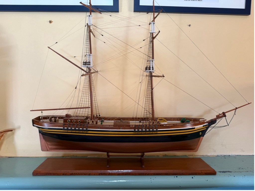
Model of the ‘Lady Nelson’ [ Inner Light Museum, Nelson Bay, built by Jim Devonshire in 1994]
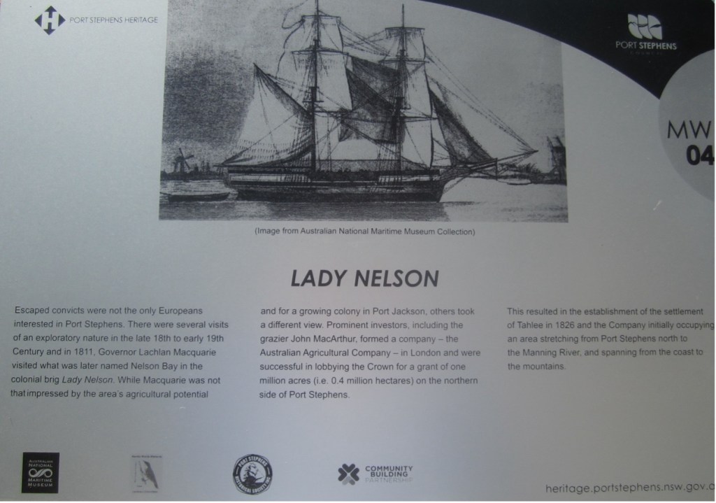
The ‘Lady Nelson’ as commemorated by Sign No. MW 04, of the Mariners Walk Heritage Trail, situated on the shores of Salamander Bay, Port Stephens
Researched and compiled by Kevin McGuinness
February 2025
