

Introduction
Canals are currently used throughout the world for navigation purposes. Many systems can accommodate large vessels. Canals are also used for irrigation, flood mitigation and also recreational purposes. While the advent of more efficient forms of transportation has reduced the need for canals, they still play a vital role as conduits for transportation and fostering commerce.
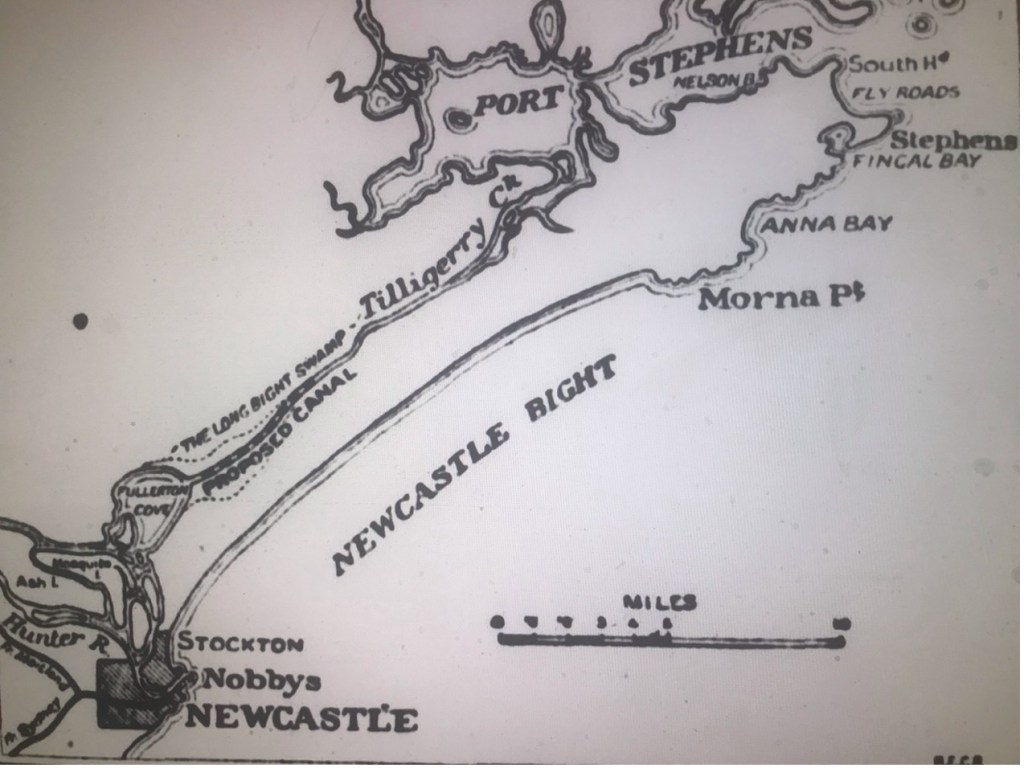
There were proposals for two canal developments put forward for the Port Stephens area in the period 1870 -1921.
The Newcastle Sun of 1 September 1919, page 3, provides a summary of the two main canal proposals over the that period:
‘There are extant two proposals for canal connection. ….. Forty years ago the Government surveyed the route of a proposed canal from the junction of the William and Hunter Rivers at Raymond Terrace to Port Stephens. The other proposal was for a canal direct from Fullerton Cove, Port Hunter, to Tilligerry creek, which broadens into an arm of Port Stephens. The first proposal was largely in connection with the problem of flood mitigation; but various engineers considered that it would not be of sufficient benefit to the district to justify the expenditure. The second proposal, it is held, could be carried out by the comparatively simple method of using sand-pump dredges. The first plan was for a waterway about eleven miles long; the second, only about seven miles.’
However, neither came to fruition. This paper outlines a history of the two main proposals which highlighted many positive advantages for the Port Stephens region.
(1) A FLOOD MITIGATION CANAL
Report of the Hunter River Floods Commission – 1870
The Newcastle Chronicle of 22 November 1870, page 2, carried a report on the findings of the Hunter River Floods Commission. An extract of the newspaper report is set out below:
‘The final report of the Commission appointed in May, 1869, to enquire into and report upon the best means of mitigating or pre-empting the evils occasioned by floods in the district of the Hunter River, has just been issued from the Government Printing Office. This elaborate report was, of course, looked for with great interest by the Hunter River community, and, indeed, by the inhabitants of other rivers in the colony liable to inundation ; and its preparation having occupied upwards of twelve months, it was fully expected that the Commission would be able to propose some scheme whereby the dire calamities which usually attend heavy floods, would be averted; but all who may have buoyed themselves up with such expectations will now experience a disappointment which they never anticipated.
The Commission, notwithstanding the pains they took to procure authentic data on the subject, have been unable to devise any effectual scheme for the prevention of floods, without incurring an expenditure of from £1,700,000, to £5,000,000, the loan of which enormous amount the Government would, we are certain, never sanction ; and it would be ridiculous to suppose that it could be raised by private enterprise. It may, therefore, be safely concluded, that flood disasters cannot be prevented, and the residents of the Hunter must put up with such visitations for the future as they have hitherto done.
Various projects for mitigating these evils have been carefully considered by the Commission, and especially those of cutting a canal from Singleton to Lake Macquarie, or from Oakhampton — about a mile above West Maitland — and Hexham ; but, according to careful calculations made, both these schemes, taking the lowest estimate, would involve from ten to five millions sterling in earthwork itself not to speak of other attendant expenditure. ln the case of a canal to Hexham — supposing such a project was carried out — the Commission are of opinion that the harbour of Newcastle, and the river as far up as Hexham, would be materially injured thereby, so much so as to necessitate considerable work in dredging both from time to time. ………….
The report closes as follows : — There is but one more scheme for relieving the Hunter which requires any notice. It has been proposed to cut a channel from some part near Raymond Terrace to Tilligerry Creek, which flows into Port Stephens. The distance is eight or nine miles, through what is said to be low swampy country. Such a cutting, if large enough, would, no doubt, relieve the Hunter. Tilligerry Creek is described as a narrow tidal inlet with low banks, which would, of course, be inundated if any considerable quantity of the waters of the Hunter were conducted that way. If none of the country through which the new cut would pass, nor the land on the bank of the Tilligerry Creek were occupied, or of any value, it might be worth while to consider whether the flood-waters of the Hunter might not thus be disposed of. It appears, however, that some of the country is valuable and is occupied, and that one end proposed to be accomplished by the new channel is to drain this area. It is desirable, of course, that this should be accomplished, if practicable, by improving the natural outfall through Tilligerry Creek; but it is difficult to understand how the introduction of the flood-waters of the Hunter would assist the process. The distance from Raymond Terrace to the sea is less by way of the Hunter than by way of Tilligerry Creek, and therefore nothing could possibly be gained by the proposed cutting, which could not be more easily and cheaply accomplished by enlarging the existing channel. We are obliged then, finally, however unsatisfactory the conclusion may be to us and to others, to state plainly that, beyond the protection of the town of West Maitland, we are unable to recommend any works for preventing the overflow of the Hunter in times of flood.’
The Maitland Mercury and Hunter River General Advertiser of 26 September 1878, page 5 advised on actions taken to further examine the Raymond Terrace to Port Stephens canal:
‘Instructions have been given to the Assistant En-gineer, at Newcastle, to have surveys made between Raymond Terrace and Telligerry Creek, for a canal, as recommended by Mr. Clark, Hydraulic Engineer, in connection with flood prevention on the Hunter River.’
Second Proposal for a Flood Mitigation Canal from Raymond Terrace to Port Stephens – 1895
Following flooding at Maitland, The Australian Star of 7 February 1895, page 6, reported:
‘A public meeting was held at Raymond Terrace last night to devise some scheme for the prevention of floods. It was decided that a canal from Raymond Terrace to Port Stephens was desirable, and that to obtain this the support of all local bodies be obtained and a deputation wait on the Government. A flood prevention league was formed, and 100 names enrolled.’
The Newcastle Morning Herald and Miners’ Advocate of 9 June 1896, page 5, reported on later action taken to promote the flood mitigation scheme concerning the Hunter River:
‘Upon the representations of Mr. R. A. Price, M.P., dealing with the proposal for the construction of a canal or by-wash [a cut to divert the flow of water] between the junction of the Hunter and Williams Rivers [at Raymond Terrace] and Pipeclay Creek, Port Stephens, the Minister for Works has agreed that the officer in charge of the proposed scheme for the mitigation of floods on the Hunter generally, Mr. E. B. Price, C.E., shall proceed to Raymond Terrace and furnish a report on the proposal. A party, consisting of Mr. Price, M.P., Mr. R. H. D. White, M L.C., Mr. J. Gillies, M.P., and others, in conjunction with Mr. E. B. Price, will leave Sydney by the 9 a.m. train tomorrow morning.
Upon arriving at Hexham they are to be met by the Mayor of Raymond Terrace (Dr. Meredith), members of the local council, and of the Hunter River Flood Mitigation Committee, and they will be driven to Raymond Terrace, where, after luncheon, evidence will be taken from persons interested with reference to the scheme. On Wednesday the party will ride over the various routes for the proposed canal, and will also inspect by steamer the sites for the inflow and outflow of the proposed bywash [canal].
This scheme will form part of the joint scheme for dealing with the whole Hunter River valley, and will be part of a composite system, which includes storage reservoirs at Denman, and conduits or cuttings between Singleton, Maitland, Morpeth, Miller’s Forest, Raymond Terrace, and Hexham. It is anticipated that the carrying out of this scheme will effect a considerable saving in dredging, no less than 3,000,000 tons of silt having been taken from the Hunter River in 1894, according to the reports of the Harbours and Rivers Department. In addition to this the Railway Commissioners pointed out in their 1894 report that the cost entailed for repairs to the permanent way caused through flood damage, amounted to £240,000.
The construction of the bywash [canal] would, it is contended, cause the silt which is in solution in the flood waters to be deposited on the flats, sand reaches, and swamps lying between Port Stephens and the Hunter, and the facilities given for the discharging of a larger volume of water in flood time into the extensive harbour at Port Stephens would, it is urged, save from inundation Miller’s Forest, Raymond Terrace, and Morpeth, and when taken in conjunction with the Denman impounding reservoirs would be the means of saving Singleton and East and West Maitland. The discharging capacity of the Hunter River at Narrowgut, Hexham, Pitnacree, and other places as computed by Sir John Coode, and Messrs. Darley, Moriarty, Gordon, and other specialists, clearly proves that increased facilities must be given for the discharge of the waters during flood time, and it is argued that the construction of the canal in question will save from inundation and loss the various towns and places along the route.
The Denman scheme alone, whilst saving the higher reaches of the river, is practically useless—so far as the lower reaches of the river are concerned—provided the Williams, Paterson, and Hunter Rivers are simultaneously in flood as in 1893, and it has been found, according to some persons, that the effect of the cutting at Wallis Creek, Maitland, and the improvements around Morpeth have caused an increase in the height of flood waters at Morpeth with a smaller rainfall as much as 4½ inches. The Crown, in that case, would also be open to actions at law for injury to riparian rights, whereas the scheme now proposed as a whole would remove that obstacle, and greatly enhance Crown and private lands by depositing silt upon lands now practically useless. It has been suggested that the betterment principle should be applied to this general scheme, which, it is estimated, would cost fully £1,000,000 sterling, but which in addition to the local advantages would be a national work, and would provide an avenue of employment to many distressed people in the Newcastle district.’
The massive water pollution that would be caused to Port Stephens and surrounding settlements was not considered in the analysis of the scheme’s advantages.
Inspection of the Route of the Prevention Scheme – 1896
The Newcastle Morning Herald and Miners’ Advocate of 10 June 1896, page 5, reported:
‘In connection with the proposal for the construction of a canal or bywash between the junction of the Hunter and Williams Rivers [Raymomd Terrace] and Pipeclay Creek, Port Stephens, Messrs. E. B. Price, C.E., of the Public Works Department, Mr. R. H. D. White, M.L.C., and the member for Gloucester, Mr. R. Atkinson Price, reached Hexham by the mail [train] yesterday. They were met there by the Mayor of Raymond Terrace, Alderman Shields, and others, and were driven to Raymond Terrace. ….. The member for Gloucester, Mr. R. A. Price, M.P., in introducing the deputation, pointed out that taking the history of the various floods and the calculations made by the various officers proved that a fall of 1in. of rain in 24 hours over the area of the water shed—viz , 12,000 square miles—meant a total of 190,000 cubic feet of water per second, and that the carrying capacity of the river amounted to 132,000 cubic feet at Singleton, 80,000 at Raymond Terrace, 17,000 at Narrowgut, and 72,000 at Hexham. It was seen from the Railway Commissioners’ report that 11in. of rain fell in 13 hours during the 1893 flood at Morpeth, and that the amount of injury to the railway work was about £210,000.
From the calculations made it appeared that unless some auxiliary channel were made the country would suffer from periodical inundations, and great loss must ensue, as the discharging capacity of the river was not equal to the quantity of water it had to carry. Mr. R. H. D. White, M.L.C., dealt with the proposal of the new canal and the history of past floods, and furnished data bearing on the case. The various members of the deputation also placed their views before the engineer. Mr. E. B. Price, in reply, pointed out that he had inspected the Upper Hunter and the Williams. He could not express a definite opinion upon the proposals but would consider the representations made by the deputation. He proposed to go over the route on Wednesday and would then be in a better position to express an opinion on the matter.’
The Sydney Morning Herald of 11 June 1896, page 5, provided further information on the activities of the inspection of the proposed canal route:
‘The engineer in charge of the Hunter River flood scheme, Mr. E. J. Price, C.E., accompanied by the Hon. R. H. D. White, M.L.C., Mr. R. Atkinson Price, M.L A. for Gloucester, Messrs G. Pepper, J. Moy, and others, proceeded along the various lines of route of the proposed canal from the Hunter River to Port Stephens. The party crossed the Campvale Swamp, and found, upon checking the measurements, that the height of the swamp, which is about 6000 acres in extent, was much above high-water level.
The next portion visited was Moffat’s Swamp, and next the line Black Camp Swamp was inspected. These contain about 4000 acres, the Black Camp Swamp being nearly on a level with the water at Port Stephens. The water would flow into the latter harbour if facilities were given for the waters to run. It is also practicable to drain the whole of Moffat’s and Campvale waters into either the Tilligerry Creek or the Pipeclay Creek, Port Stephens. After inspecting the surrounding country the party rode to the other proposed inlets on the Hunter, one being situated next the boat harbour and the other at Windeyer’s Creek, Raymond Terrace.
During the journey information as to levels was obtained, and in the evening a meeting of the municipal council and the residents was held, when the Mayor, Alderman Dr. Meredith, presided. A discussion of a conversational character took place between the council and Mr E. B. Price, C E., when various matters in relation to the proposed schemes were considered. Information in reference to floodwaters and levels and rainfall was furnished to the engineer.’
The National Advocate of 12 June 1897, page 2, reported of on the final Government decision not to proceed with the Raymond Terrace to Port Stephens flood mitigation canal:
‘Mr. E. B. Price, assistant engineer, Department of Public Works, having exhaustively examined the Upper Hunter, the Goulburn and minor tributaries, has made a report to the Minister, suggesting means of flood prevention. The document was laid on the table of the Legislative Assembly on Thursday night. ……The works at Newcastle would be most beneficial; but the canal from Raymond Terrace to Port Stephens, he rejected, as impossible. It would cost over a million.’
Proposal to Appoint a Royal Commission to Examine the Flood Mitigation Issue – 1898
The Maitland Weekly Mercury of 26 November 1898, page 13, reported on the proposed establishment of a Royal Commission to examine the methods of mitigation floods in the Hunter region and surrounding districts:
‘We are informed that the Premier had a conversation with Mr. R. A. Price, M.P., last week on the question of flood mitigation in the Hunter, and referred to the fact that it had been decided to appoint a Royal Commission to consider the various schemes which had been propounded. Mr. Price remarked that certain information required by the various engineers who had made their reports was not available. It was necessary to ascertain the catchment area of the Hunter; the Williams, and the Paterson and tributaries to get a contour survey of the country at the heads of the rivers with the object of ascertaining whether a series of impounding reservoirs could be constructed; …… full particulars of the country between Raymond Terrace and Tilligerry Creek, as to the advisableness of constructing a canal between Fullerton Cove and Salt Ash, the advisableness of deepening and widening Settlers’ Drain, between the Hunter and Port Stephens, and of cutting a canal from Raymond Terrace to Swan Bay, Port Stephens. The Premier promised to increase the scope of the inquiry in the directions indicated. — We have reason for saying that the Commission when appointed will be composed of gentlemen in whom the people may have confidence. Probably some able civil engineer outside New South Wales will be included in it. And it will investigate the problem with a view of solving it not of shelving a “perplexing question.” ‘
The Sydney Morning Herald of 24 February 1899, page 3, reported that a Royal Commission would not to be appointed:
‘Mr Price asked the Premier, without notice, whether he would inform the House when the Royal Commission which he had promised would be appointed to devise means of mitigating floods on the Hunter River.
The Premier, in reply, said that the gentleman whom they had proposed to obtain for the purpose had been engaged by the New Zealand Government hence the delay. But that gentleman, Mr Napier Bell, who came to them with high credentials, would be appointed to make a personal examination of the problem without the circumlocution of a Royal Commission. If afterwards it was thought that a Royal Commission would expedite matters, Mr Napier Bell would be appointed for the purpose of taking evidence and reporting upon the matter.’
Mr Napier Ball delivered his report on remedies for the Hunter River flood issues during July 1899. His list of remedies did not include a canal to Port Stephens as an option. The Newcastle Morning Herald and Miners’ Advocate of 28 July 1899, page 7 summarised the findings as follows:
‘The report of Mr. C. Napier Bell, who was instructed by the Government to inquire into the cause and probable remedies of the Hunter River floods, has been published. The report concludes:—”To straighten the river between Maitland and Morpeth, and enlarge the river bed up to Belmore Bridge, would, by this estimate, cost about £200,000, which is a very large sum, but it would relieve Maitland and the Bolwarra districts of all anxiety from floods. Besides this, I recommend that two bends above the Williams be cut through, the obstructions at Green Rocks removed, and, a deep cut be made through the shoals of the North Channel. These would cost £253,065. The total estimate for improving and embanking the whole river is £1,076,600, which is about £130,000 more than I estimate that Mr. Price’s proposed dam would cost, and it is a much safer and more trustworthy way of alleviating the floods of the Hunter.” ‘
Public Works Committee Report – 1903
Since Mr. Napier delivered his report, other examinations and reports on the flood issue have been undertaken from time to time. The first of many examinations was a Public Works Committee, that was formed in 1901, and reported during August 1903. The committee examined many new flood mitigations options and reviewed the previously promoted schemes of utilising canals to Port Stephens for drainage and dismissed these as unsuitable.
The Maitland Weekly Mercury of 15 August 1903 reported on one of the schemes reviewed by the Public Works Committee:
‘Mr. Gordon, in his report upon the mitigation of floods in the Hunter, remarks that to attempt to “take off the top of the flood” by diversions to Port Stephens would be not only impracticable but preposterous, and Mr. Napier Bell, in his report, is of a similar opinion.’
(2) A NAVIGATION CANAL
Proposal for a Navigation Canal Between Port Stephens and Newcastle – 1872
During 1872 a meeting was held at Williamtown by residents to establish a committee to Lobby for the construction of navigation canal between Newcastle and Port Stephens. The Sydney Morning Herald of 19 January 1872, page 6, reported:
‘For a considerable time past public attention has been directed to the desirability of creating a trade between Newcastle and Port Stephens that would ultimately prove beneficial to the two ports, and at the same time constitute a prolific source of income to a large number of persons. Hitherto, the distance by water, and the danger to small craft trading in certain weather between the two places, have deterred capitalists from investing their means in opening up probably one of the richest mineral and agricultural districts in the Australian colonies; and, although many allotments have been purchased, and in some places are even under cultivation, owners prefer to allow their produce to go to waste, rather than convey it to Newcastle for sale, the expense of which renders them unable to compete with producers residing nearer the market; and thus our trade with Port Stephens has been confined to a few instalments of dried fish and oysters, and shipments of timber.
A method has been suggested, however, whereby water communication with Port Stephens may be had in another direction, and, should the project be carried out successfully, it is impossible to overestimate the commercial advantages that will be conferred on a rich alluvial district, extending many miles northerly, and easterly from William Town to the waters of Telegare [Tilligerry] Bay.
Williamtown …. is destined to play an important part in the present movement. It is through land held here by a number of settlers that the proposed canal will have to be cut, providing the Government can be induced to agree to terms that are to be proposed to them.
Williamtown, a plain about nine miles from Newcastle, and two miles and a half from the North Beach, is bounded on the south-east by the White Sand Hills, which extend for several miles parallel with the land under cultivation. ….. The farmers resident in this locality now propose to ask the Government to have a canal cut through their rich alluvial land, accepting as compensation the advantages they will derive from an increased trade with Port Stephens and Newcastle, and the opportunity that will be afforded them of conveying their own produce to a ready market by water. The cost of carrying out this work has been estimated at £5000, and considering the tract of country that will be offered to the Government, we hardly anticipate a refusal to so reasonable a demand.
The direction of the canal, …. would be from Fullerton Cove Bay to that point of Tellegare [Tilligerry] Creek which abuts on Mr. Henry Smith’s land, a distance of exactly five miles, the Creek being one of the offshoots of the harbour of Port Stephens. The distance from Fullerton Cove Bay to Newcastle’s is little under six miles, so that the entire distance between the two ports, by river navigation, would be under eleven miles, and the smallest craft could traverse it in the most tempestuous weather with perfect safety.
Telegare [Tilligerry] Creek runs through Government land, which is rich in minerals, limestones for agricultural purposes, of the best description, and well timbered. It is believed, and not unreasonably, that this will be so far enhanced in value that the Government will, in the event of their contenting to carry out the proposed work, be enabled to sell it at such an increased price as must defray the entire cost incurred. One great advantage, too, to farmers is that none of this land is subject to floods. The depth of water in the creek is very considerable, but Fullerton Cove is comparatively dry at low water, whilst at flood tide it is covered to a depth of six to eight feet.
A meeting of the promoters, who are principally residents of Williamtown, was held at the residence of Mr. Lavis on Monday afternoon, for the purpose of considering the most desirable way to bring the matter under the notice of the Government without delay. Mr Myers, a resident of thirty-two years at Port Stephens, occupied the chair, and there was a numerous attendance of landholders. ….
The chairman explained the object of the meeting and said no one could doubt the necessity of persevering in the present movement until it was brought to a successful issue. He also pointed out at some length discourse which he thought ought to be taken to secure this end. The proceedings were of a conversational character, but it was stated that the nature of the soil was such, that if a canal were cut the land would not require “facing,” so that considerable expense would thus be avoided. It was also suggested that the following conditions should be submitted to the Government: “We, the undersigned, are agreeable to give the Government land that will be required for the proposed canal without compensation, on condition that the land be left open without gates, as it will not answer to dam the salt water back on to the alluvial land. 2. That in case of any farm being divided in two by the canal there be some sort of bridge erected, so that cattle may be enabled to pass over. 3. That the landholders be permitted to drain the surplus water off their land into the canal through sliding gates in the bank.”
After considerable discussion, it was decided that the above conditions should not be submitted until it was ascertained whether the Government entertained the primary object in view.
Mr. George Rooke, who had been requested to prepare a statement for the information of the meeting, handed in the following -“Telegar [Tilligerry] Creek is navigable for moderately sized vessels for seven miles from the termination of Henry Smith’s land, on which the creek abuts. A canal seven miles long would connect it [Tilligerry Creek] with Fullerton Cove at a point distant from Newcastle about six miles. Telegare Creek runs through Government land, well timbered, not subject to floods, and a large portion suitable for gardens, orchards, farms, or vineyards. The productions of Port Stephens and its tributaries are various and considerable in extent, and would in a short time lead to a large trade with Newcastle. There is farm produce of all kinds from Borrel, Myall, Limeburners’ Creek, also timber of all descriptions, oysters, fish (dried and fresh), shells, and rock lime, which has been highly approved of in Sydney, and I believe there are some 300 miles of water frontage to the Government land, in the Bay of Port Stephens. George Rooke.”
The above statement was unanimously adopted by the meeting.
Mr. Rooke then proposed, and Mr. Lavis seconded, “That a committee consisting of Messrs Rooke, Joseph Lavis, J. Russell, R. Myers, A. Mortimer, John Lavis, H. Slade, with power to add to their number, be appointed to draw up a petition for circulation throughout the districts of Raymond Terrace, Myall, Burrell, Telegare, Port Stephens, and other townships in the neighbourhood, for presentation to the Government, praying that a canal be cut between Telegare Creek and Fullerton Cove, for the purpose of opening up water communication by this means between Port Stephens and Newcastle.”
Renewed Proposal for a Navigation Canal Between Port Stephens and Newcastle – 1894
The Newcastle Morning Herald and Miners’ Advocate of 26 October 1894, page 5, reported:
‘A meeting of the northern district members was held at Parliament House this afternoon with reference to the proposal to cut a canal from Port Stephens to Newcastle. Mr. R. G. D. Fitzgerald, member for The Hunter, occupied the chair. …. Among those present were Messrs. Eddon, Watkins, Stevenson, H. H. Brown, and the convener of the meeting, Mr. Price. A discussion took place as to the respective merits of the canal from different points. It was ultimately decided that the question as to the points at which the canal should be started from either side should be left to the officers appointed to report on the scheme. It was determined that a deputation of members should wait on the Minister for Works to urge upon him the desirability of obtaining a report upon the proposed construction of the canal, and arrangements with regard to a deputation were left in Mr. Price’s hands. The deputation will not wait on the Minister for at least a week, and meanwhile Mr. Price will be glad to receive suggestions from councils and other local bodies upon the proposal. Mr. Brunker will introduce the deputation to the Minister.’
A Canal Could Assist Claim of Port Stephens to be Federal Capital Site – 1899
During 1899 and subsequent years, the search was on to decide on a site for the new Federal Capital site. Many localities in New South Wales put forward bids advocating their area as the prime location for the new Federal Capital site, and advocates from Port Stephens, also placed their claim. The following article from the Maitland Daily Mercury of 13 February 1899, page 6, promotes the idea that a canal between Fullerton Cove and Tilligerry Creek would assist the claim of Port Stephens as the best site:
‘Mr. R. A. Price, M.P., has asked the Premier if he will take into consideration the advantages offered by Port Stephens as a site for the Federal Capital. The member lays stress upon the fact that a light line of railway could be constructed to connect with the main north railroad at Hexham or Tarro, and that water communication could be provided by deepening the channel between Fullerton Cove and Tilligerry Creek.’
Further Proposal for a Navigation Canal Between Port Stephens and Newcastle – 1909
The Casino and Kyogle Courier and North Coast Advertiser of 20 February 1909, page 4, reported:
‘Mr. John Thompson, M.H.R. is moving in a most important matter. That is the proposal to cut a canal from Salt Ash (head of Port Stephens) into the Hunter, in order to relieve the congested shipping of Newcastle harbour and to shorten the trip by the Lakes route, providing, as it would, continuous water travelling from Bungwbal to Newcastle. The neck of land is but a few miles across and is of low and swampy nature. The new waterway will admit of large vessels trading to Newcastle making use of the ex-tensive harbour of Port Stephens.’
Naval Officer’s Opinion on the Canal – 1911
The Gloucester Advocate of 5 August 1911, page 11, reported on a naval officer’s opinion concerning the harbour of Port Stephens:
‘The whole of the naval officers who visited the port last week were loud in their praises of its suitability for a naval base and city…..One thing struck Captain Chambers as quite worth further investigation on the part of the State authorities, and that was the possibility, of cutting a canal from Port Hunter to Port Stephens. The intervening country was low-lying, and could be cut at a very moderate cost by utilising big machines like those used on the Panama cutting, the soft earth could be displaced quickly, and a canal made that would be a valuable means of communication between Port Hunter and Port Stephens.’
Preliminary Investigation of Canal Proposal – 1915
The Sydney Morning Herald of 12 June 1915, page 16, reported:
‘The Assistant Treasurer, Mr. H. C. Hoyle, is just now in the Newcastle district, investigating in a preliminary way an important scheme in connection with the port of Newcastle and Port Stephens.
Map showing the proposed Hoyle scheme for connecting Port Stephens with Newcastle
It is proposed to establish a harbour trust to control the northern harbours from the Hawkesbury River to the Queensland border, taking in Newcastle and Port Stephens. The fatal bar in the past to any such proposal to bring Newcastle and Port Stephens under the one harbour trust has been the supposed conflict of interests between the two harbours. Port Stephens is within a few miles of Newcastle, and its natural advantages as a port are much greater than those of its neighbour, and a scheme has been suggested to the Minister where the interests of the two places might be harmonised.
The scheme, briefly, is to dredge and deepen Tilligerry Creek, on the south side of Port Stephens, and extend it five or six miles till it meets the port of Newcastle at Fullerton Cove. The route of the proposed canal is level and sandy, so that it is considered there will be no great physical difficulty in the way of carrying it out.
The advantages claimed for this canal scheme are that vessels would be able to leave or enter Newcastle by the artificial waterway in all kinds of weather. Port Stephens is the haven for coastal craft in rough weather, and it is to be made a naval base, it being said that a whole fleet could be floated in Salamander Bay. Motor boats at present ply on Tilligerry Creek, which already has a good depth of water.
After Mr. Hoyle’s personal inspection of the locality, and consultation with local authorities, he will call for further details on the project.’
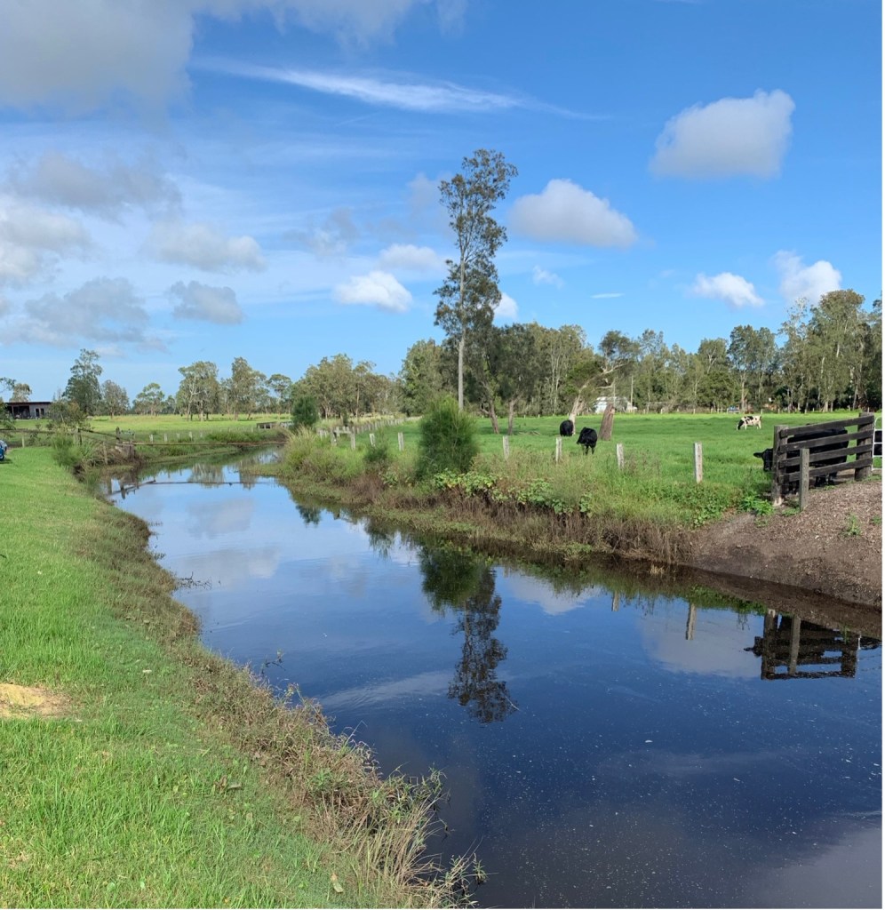
Tilligerry Creek at Salt Ash showing its potential for conversion to a navigable canal. [Author Photo – March 2022].
Canal Proposal Considered at Shires Conference – 1921
The Newcastle Sun of 9 June 1921, page 5, reported:
‘An important conference took place yesterday at Raymond Terrace between the Port Stephens Shire and other local governments in the vicinity of Newcastle, at which Mr. R. A. Price, M.L.A. was present. …..A large number of districts were represented. The following subjects were dealt with:— (1) Flood mitigation of the whole of the Hunter River valley and its tributaries. (2) The construction of a canal, by excavation and the throwing up of the materials excavated for a tow-path, between Fullerton Cove and Port Stephens [Tilligerry Creek]. …… Inspector Davis, of Newcastle, has received instructions to proceed to the places at once.’
The Newcastle Sun of 20 July 1921, page 4, provided further information on the council conference:
‘At a meeting of councillors of the shires in the vicinity of Port Stephens, held some time ago, it was decided to approach the Government with a view to opening up the port. One of the suggestions was the construction of a road to Nelson’s Bay from Stockton. Another suggestion, and by far a more important one, was the opening of a deep ship canal between Tilligerry Creek, Port Stephens, and Fullerton Cove, Port Hunter.
There is not the slightest doubt that, in remote ages, Port Stephens was the natural outlet of the Hunter River, and the opening of a canal between the two places could be carried out by the removal of a bar that has silted up. Port Stephens is one of the finest ports of the Southern Hemisphere, and there is no reason why Newcastle, which is fast becoming the greatest industrial city of Australia, should not utilise the port for the export trade which is growing up. There are no engineering difficulties to overcome, and even if there were, the advantages of having a great port for a great Industrial centre should outweigh anything on the score of expenses or difficulty.’
Despite repeated calls for the construction of a navigation canal, no Government endorsement of the scheme was to eventuate.
American Land Development Company Proposal – 1923
In 1923, much publicity was given to a proposal by an American business syndicate to develop of a large area on the northern side of Port Stephens, at Tea Gardens, into a large residential city and factory complex. As part of the overall concept, the company also proposed the construction of a canal from Port Hunter to Tilligerry Creek.
The Maitland Weekly Mercury of 23 June 1923, page 11, reported:
‘They will use … Port Stephens as their harbour. Should the negotiations which are said to be almost complete be effected, it is in the mind of the company to confer with representatives of the Government with a view of cutting a canal from the head of the waters of Port Hunter to meet the waters of Port Stephens at the head of Tilligerry Creek, which for nine miles runs down to meet the waters of Port Stephens Harbour. This, in the opinion of the representatives of the company, is the largest and best in Australia, and it is this fact that has made the Americans enthusiastic in regard to the potentialities of the harbour, which has for years been used simply as a channel for small steamers, dealing in a minor way with timber and farming produces within convenient range of the harbour.’
Concluding Comments
While the two canal proposals never received the necessary government backing to enable construction, the idea of a navigational canal link still lives on.
A local Traffic and Transport Engineer, first proposed a plan for a high speed Rivercat Ferry service between Fullerton Cove and Newcastle airport in 1991. They were still promoting the idea in an interview on community radio station 2NURFM on 25 August 2017.
The link would be created along a canal, parts of which would have to be excavated, from the north shore of Fullerton Cove to Newcastle Airport, a distance of four kilometres.
While this scheme may have much to commend it, one hundred and fifty-four years have elapsed since the concept of a canal in the Port Stephens region was first proposed in 1870 and is still unable to obtain any official approval.
Researched and compiled by Kevin McGuinness
April 2024
