

In 1934 and 1935, academics and students from Sydney University undertook two scientific expeditions in the Myall Lakes area. The expeditions were the first comprehensive scientific studies undertaken there.
The two studies examined the geology of the area, as well as the vegetation, fauna, insect life, bird species and marine life. The reports of the various findings greatly added to the community’s knowledge and appreciation of the area.
First Scientific Survey – 1934
The Newcastle Morning Herald and Miners’ Advocate of 23 July 1934, page 6, reported:
‘The Myall Lakes district is to be made the subject of a scientific expedition by a party of scientists from Sydney University. The party is being organised by the University Rover Scout crew and will include members of the University staff and students. Professor T. G. B. Osborn will lead the expedition. It will leave Sydney for Newcastle by boat on August 19. It will travel from Newcastle to Bulahdelah by motor ‘bus and will then proceed to the camp site on the Broadwater by launch. Other members of the University staff who will join the expedition are Professor H. Priestley, who will be second in command, Mr. Alan Colefax, and Mr. K. W. Salter (Curator of the Macleay Museum).
The expedition will be divided into several groups, which will study the district from different scientific aspects. Mr. Colefax will lead the group studying marine biology, and Messrs. R. N. Robertson and S. W. Carey will lead the botany and geology sections respectively. Mr. W. H. Maze will accompany the party as probably go as entomologist.’
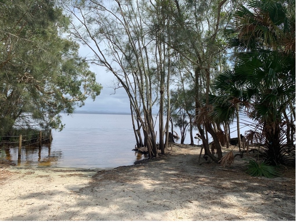
The Broadwater of Myall Lakes – adjacent to the sites used by the scientific expedition at Mungo Brush [Author photo]
Scope of the Survey
The Sydney Morning Herald of 18 August 1934, page 20, reported:
‘The area has occasionally been visited by scientists but has never before been the subject of a scientific inventory. The geographers with the expedition intend to prepare a better map, embodying the detailed information supplied by the other sections of the expedition. The geological section will attempt to elucidate the geology of the area. The botanists will endeavour to work out the distribution of the various types of vegetation and establish the limits of the various plant communities. The entomologists will collect all the types of insects available in an effort to catalogue all the insect forms occurring in the area. A list of the birds found in the area at this time of the year will be prepared by the ornithologists. The marine biologists will take samples of the waters of the lakes, to elucidate their microscopic flora and fauna and their chemical content. The soil of the district will also be surveyed and its possibilities for agriculture will be investigated.’
Expedition Commences Work
The Manning River Times and Advocate for the Northern Coast Districts of New South Wales of 29 August 1934, page 3, reported:
‘The camp is in a picturesque setting, amid country which offers great scope for scientific study in many and varied fields. The object of the expedition is to make a preliminary survey of this interesting area, which as yet has not been thoroughly investigated from a scientific point of view. The party arrived on Monday afternoon of last week. Laboratories were set up and the scientific apparatus unpacked. Heavy rain hindered field work for the early part of the Tuesday, but when the weather had cleared short expeditions were made into the adjacent country by small parties under the guidance of botanists and entomologists.’
Progress of Myall Lakes Study
The Sydney Morning Herald of 30 August 1934, page 13, reported:
‘Patches of remnants of tropical jungle have been found by the scientific expedition organised by the Sydney University Rover Scouts, which is camped at Mungo Brush, on the Myall Lakes. Extensive swamps, heaths, and eucalypts are other features of the district.
Although heavy rain has interfered to some extent with the work of the expedition, which is engaged on a preliminary survey of a large area round the lakes, considerable progress has been made, and much laboratory work has been done. Later, a more detailed survey will be made, which, it is hoped, will produce results of definite scientific and practical value.
The botanists are attempting to compile a complete list of the plants of the district, and to determine the zones of plant types, with the reasons for the different zones. They are thus connecting the plant distribution with geology. The botanists are cooperating with a representative of the Faculty of Agriculture, who is taking samples of the soil from the surrounding districts. The area for botanical survey is extensive, and the number of different vegetation types is large.
The botanists have made collections of the different plant communities, which are varied, and have different constituents. The hills are covered in eucalyptus forests which are being widely cut out for timber. In the valleys there are fine patches of brush, with a development of bangalow palms. Nearer the coast are isolated patches of brush which differ from those of the gullies and hills. Near the lakes there are extensive paper-bark swamps. Sand dunes with typical sand-dune plants are developed round the coast.
The marine biologist has continued chemical analyses of water taken from different parts of the lakes, and from the Myall River, which connects the lakes with the sea. Catches of the small floating life in the lakes are being studied with particular regard to their bearing on the food of the fish. Information is also being collected about the habits of prawns.
The geologists have made many excursions, and the Curator of the Macleay Museum (Mr. K. Salter) has collected specimens of types of insect life of the district for the museum’s collection.
Professor Osborn (with back to camera), leader of Sydney University Rover Scouts’ expedition to Myall Lakes, and some of the undergraduates, photographed while examining botanical specimens [Newcastle Sun, 4 September 1934, page 9]
The Sydney Mail of 5 September 1934, page 41, further reported:
‘The objects of the Sydney University Rover Scouts’ expedition to Myall Lakes during the last ten days of August were, firstly, a preliminary scientific survey of the district with the idea of returning to the task in future years to perform a complete ecological survey; and, secondly, to discover what problems were to be solved.
It has been suggested that if the lakes were drained into the sea, which is only half a mile distant at some points, valuable land would be made available for agriculture; indeed, an attempt has been made to carry out this scheme, but without success. A curious state of affairs is that although the water is almost fresh ocean fish abound, and these fish must be in some way specialised in order to survive in this unaccustomed environment. Interesting geological and botanical conditions occur in the neighbourhood of the lakes. …..
The camp was situated at Mungo, on the eastern shore of Broadwater, the most southern of the Myall Lakes, on a strip of land half a mile in width between the lake and the ocean. On arrival the party was divided into patrols, and the camp was organised according to Scout methods under the direction of Mr. Willings, the senior Rover Mate. Mungo is a delightful little spot, which is famous for its patch of brush situated on a hill close to the clearing where there is a solitary galvanised-iron dance-hall, which is used by Bulahdelah holiday-makers about Christmas time. Camping fishermen and timber getters are the only other signs of settlement.’
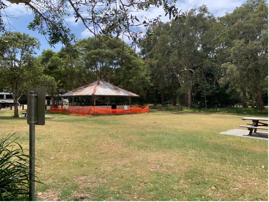
The shelter shed at Mungo Brush, Myall Lakes [Author photo]
We kept in communication with Sydney by means of short-wave wireless installed in the camp, and a portable transmitter and receiver were carried by the launch parties to maintain contact with the camp. The geographers determined that the level of the lakes was four feet below high-water mark of the ocean; thus, there is little difference between the level of the lakes and the average sea-level.
Further, the botanists and geologists were interested in the formation of sand dune and their colonisation by plants; but where the vegetation is disturbed, as in the case of pathways leading over the dunes, sand is deposited by the wind on the tracks in great quantities; so that a canal passing through the dunes would soon be blocked up by sand. The sand dunes themselves would present a formidable obstacle to such a scheme as a canal. If land were recovered by draining the lake it is questionable whether it would warrant the trouble of doing so, since little of the surrounding land is of any value.
The timber is of high quality; but otherwise, industries consist of fishing, swamp mahogany for bakers’ ovens, and tees for shipbuilding. There are a few cattle in the scrub, but they do not seem to thrive. Since the climate is suitable for the maintenance of vegetation and animals there are many birds, reptiles, and insects and occasional patches of brush. The biologists were particularly pleased with their collections. Several islands were not recorded on the maps; so that the geographers were kept very busy. Fossils of shells and marine relics were found embedded in tuff in the higher places; but otherwise, the geology of the area was uninteresting, being mostly “recent” sandy deposits.’
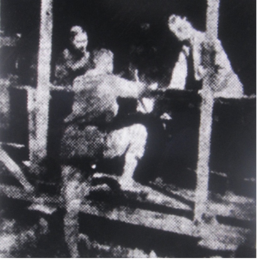
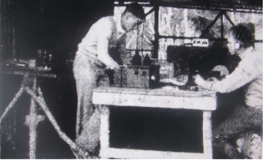
The newspaper published the following three photos of the expedition:
The wireless outfit at the camp. Communication with Sydney was maintained during the whole period of the camp
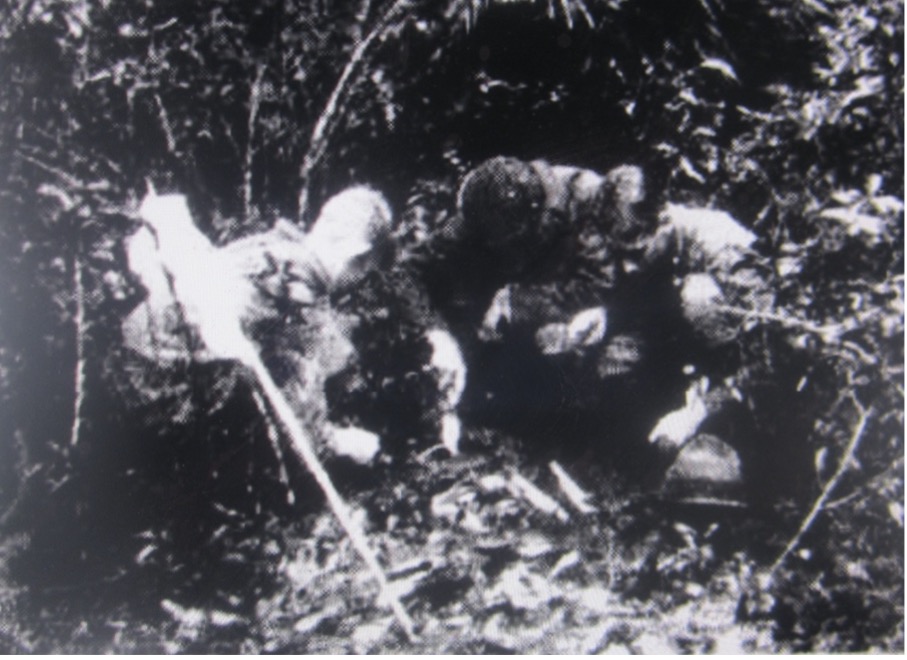
Entomologists examining a fallen tree for insects
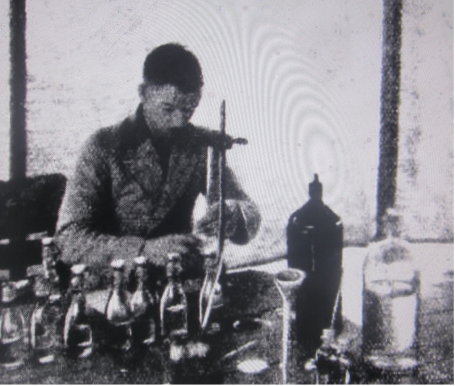
A bio-chemist examining the water samples taken from the lake
Second Scientific Expedition to Myall Lakes – 1935
The Dungog Chronicle of 7 June 1935, page 2, reported:
‘A scientific expedition organised by the Sydney University Rover Scouts, is camped at Booloombayte [north of Mungo Brush, Myall Lakes] on the Myall Lakes. The expedition includes botanists, geologists and entomologists, and is engaged in continuing the survey of the district begun last September. Professor T. G. B. Osborn is leading the party, other members of which are Associate Professor H. Priestley, Mr. A. N. Colefax (marine biologist), and Mr. K. Salter (curator of the Macleay Museum).
The Sydney Morning Herald of 8 June 1935, page 19, further reported:
‘After carrying out an intensive scientific survey in the Myall Lakes area, a party of Sydney university professors and students returned to Sydney by the steamer ‘Hunter’ yesterday. The expedition, which was in the charge of Professor T. G. B. Osborn, continued the work of a previous survey in August last. …..
Messrs. R. N. Robertson and Noel Beadle collected specimens and studied the plant ecology of the region. Mr. A. N. Colfax, of the Department of Zoology, dredged for marine and freshwater plankton in Port Stephens and the various lakes. Migratory wading birds, which at this season should normally be breeding in Siberian wastes, were found by Mr. A. J. Marshall, the ornithologist who accompanied the party. Another item of great ornithological interest was the discovery of emus inhabiting the sand-dunes and beaches on the ocean front. The emu, in these days of close settlement, is rarely found east of the Great Divide.
Reconnaissance parties were generally in touch with the base camp by portable radio, and this was found to be of inestimable value to the investigators in the field. A large collection of specimens was gathered for the MacLeay and other university museums.’
Consolidated Report of the Two Expeditions
The Sydney Morning Herald of 22 June 1935, page 20, reported:
‘On two occasions within the last eight months the Sydney University Rover Scouts have organised a scientific expedition to the Myall Lakes. The parties have included botanists, geologists, entomologists, ornithologists, marine biologists and the object of the expeditions has been the making of a survey of the district surrounding the lakes.
The Myall Lakes are not well known, and as far as tourist traffic goes, they are practically untouched. One reason is their comparative inaccessibility. They are reached by road through Bulahdelah and are distant some hundred and sixty miles from Sydney. The lakes, which are of the coastal type like Lake Macquarie, are drained by the Myall River, which flows into Port Stephens. There are three main lakes, connected by straits. The biggest one, the Myall, has the proportions of an inland sea, while the other two, the Booloombayt and the Broadwater, are somewhat smaller.
The formation of the lakes is explained physiographically as follows:—In the Tertiary period the region was one of low relief, the mountains of Eastern Australia having not yet been elevated. The development of the hills and valleys, as we know them today took place in three distinct stages. First there was a widespread crustal disturbance and uplift which resulted in the warping upwards of the lowlands to form the coastal tablelands. This high plateau was attacked by streams, the ancestors of the Myall River system, which carved deep valleys out of the plateau surface. The next important event in the development of the landscape was a general subsidence of some 400 feet, which allowed the lower parts of these valleys to be drowned by the sea which flooded the low-lands. The coast presented a jagged zig-zag outline, with no less than thirty offshore islands in the Myall district, which had been the tops of ridges in the earlier landscape.
Then began the process of reclamation, the third stage in the story, not yet completed. Sandspits developed on the south-west side of many of the islands, which, through the activity of the coastal current and its eddies, gradually extended south-westwards, eventually linking up with other low islands. Thus, a continuous sandspit was formed east of the coastline, running from island to island, which thus became headlands. So the Myall Lakes came into being as a broad coastal lagoon, studded with islands and separated from the ocean by a sandspit twenty miles long.
No sooner had the sandspits appeared above the waters through the wave action, than the winds began to assert their powers, and piled up sand dunes, and marched them inland towards the lakes. The reclamation of the lakes is still actively proceeding. We may watch their gradual shallowing through the accumulation of sand blown in by the wind, and silt contributed by the streams from the mainland; we may witness also the gradual encroachment of the fringe of reeds and waterweeds, followed by the Casuarinas and Melaleucas, and finally the swamp eucalypts. …..
The second scientific expedition, arranged by the Sydney University Rover Scouts, has just returned from the lakes alter a ten days’ camp. The first camp was held last September at Mungo, on the Broadwater. Mungo is interesting because of the patch of sub-tropical rain forest found there; it was formerly an island (a mountain peak which remained after the subsidence), but it has gradually been overtaken by the march of the mangroves and the gradual reclamation of the lakes until now it is part of the mainland.
From this point extensive surveys of the surrounding district were made. The geologists investigated the history of the development of the landscape, and the structure of an ancient mountain chain, traces of which are found in the folded structure of the ancient rocks. The botanists carried out general collecting and listing of plants, and more than 300 species were noted. The entomologists collected specimens of types of the insect life of the district, and these were carefully classified and will be added to the Macleay Museum collection at the University. The marine biologist took samples of the small floating life from different points in the lakes and the Myall River; these catches were chemically analysed, the object being to ascertain facts as to the food of the fish, which will be of importance to scientists and also to lake fishermen.
This year the expedition camped further north, on the Booloombayt Lake, and continued the work done in the previous September. Unfortunately, heavy rain during the greater part of the stay hampered the work to some extent. This was particularly the case with the marine biologists, whose samples were not taken under ideal conditions, as there was too much fresh water in the lakes to ensure a good collection of typical animal life.
However, both expeditions have compiled much data which is of considerable value. A detailed report of the first expedition’s work has been lodged in the library at the University, and a similar report of the recent survey will be available in a few weeks. It is intended to visit this area again to pursue the interesting studies begun there.’
There were no further reports of scientific expeditions undertaken by the university in the Myall Lakes area, around this period.
Epilogue
A report of the scientific expedition, dealing with the vegetation. of the Myall Lakes district was published on the internet and can be viewed at the following link: Proc. Linnean Soc., NSW, 1939, v 64
The report on the vegetation of area published the following 15 photos:
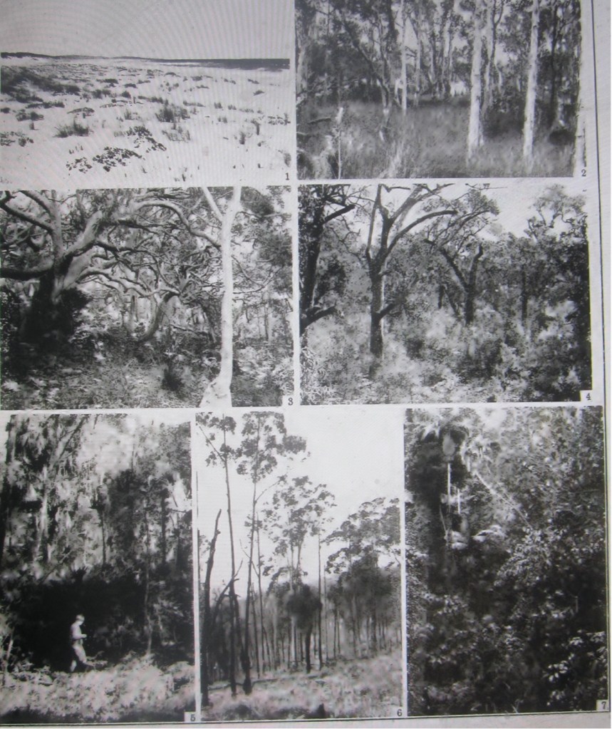

List of photos, tagged from left to right, across and down:
1. Fore dune vegetation of Festuca littoralis and Senecio spathulatus. Near South Gibber.
2. Melaleuca Leucadendron swamp forest at margin of lake, looking towards the water. Dense ground flora of Cladium junceum. Shores of Booloombayt Lake.
3. Low forest of Angophora lanceolata on stable dune near sea. Macrozamia spiralis at foot of trees to left. Undergrowth of Pteridium, Xanthorrhoea and Lomandra. Near South Gibber.
4. Eucalyptus piluraria-E. gummifera forest on deep stable sand. Banksia serrata in second storey (right foreground) and tall, shrubby undergrowth of Leptospermum stallatum, Calythrix, etc. About one-fourth mile inland opposite Bombah Point.
5. Livistona australis in swamp forest of Eucalyptus robusta, near to Mungo.
6. Mixed eucalypt forest on tuff hill. Xanthorrhoea arborea in centre, ground cover of tussock grasses and Cyperaceae. Near ‘Cutler’s’, west of Booloombayt Lake.
7. Sub-tropical rain-forest in steep sided valley of tuff hills. A society of Archontophoenox in centre. Sheltered vally to north-east of Booloombayt Creek.
8. Remains of Eucalyptus saligna, v. pallidivalvis on silt flat by Booloombayt Creek. Near northern extremity of Booloombayt Lake.
9. Sandy shore at north end of Broadwater, east of Bombah Point.
10. Heath with scattered Banksia latifolia among leptophyllous shrubs and sedge-like plants. About 2 miles south-east of South Gibber.
11. Peat swamp. Leptospermum Liversidgei, dominant, with occasional stunted Eucalyptus robusta. About 1 mile east of Bombah Point.
12. Peaty swamp with Blachnum serrulatum. About 1 mile east of Bombah Point.
13. Poor grass-land with tussocks of Carex paniculata on tuff hill, forming part of peninsula in Booloombayt Lake.
14. Mixed eucalypt forest on tuff hill. North-east of Booloombayt Lake.
15. Natural regeneration of mixed eucalypt forest on tuff hill. Near the northern extremity of Booloombayt Lake.
Researched and compiled by Kevin McGuinness
October 2023
