
Introduction
HMS Beagle was launched in Woolwich Dockyard in London on 11 May 1820 for the Royal Navy. She was a Cherokee-class 10-gun brig-sloop and was one of more than 100 ships of this class that were built.
As there was no immediate military use for the Beagle, it lay idle for a period before being fitted as a survey vessel.
It made three voyages of discovery throughout the world. The famous naturalist, Charles Darwin, undertook his groundbreaking scientific studies on the second voyage and therein laid a claim to fame for the ship itself.
The first voyage of HMS Beagle (1826 – 1830) was part of an expedition in the company of HMS Adventure to complete a hydrographic survey of Patagonia and Tierra del Fuego. It left Plymouth, England, on 22 May 1826. The overall command of the expedition and of HMS Adventure was in the hands of Australian Captain Phillip Parker King. The Beagle was under the initial command of Captain Pringle Stokes. He was later replaced by Captain Robert FitzRoy.
The second voyage (1831 – 1836), with young Charles Darwin on board, left England on 10 December 1831, under the command of Captain Robert FitzRoy. The expedition completed surveys in South America, before returning to England on 2 October 1836, via New Zealand, Sydney, and Hobart. The travelogue and scientific journals of Charles Darwin were first published in 1839 and reprinted in many editions of what we know as “The Voyage of the Beagle”.
The third voyage of the HMS Beagle (1837 – 1843), was undertaken to survey large parts of the unchartered Australian coastline, under the initial command of Captain John Clements Wickham. He was replaced by Captain John Lort Stokes in March 1841.
The Beagle left England on 5 July 1837 and reached the Swan River (near Perth) on 15 November 1837. Over the following years it undertook various exploratory voyages in Western Australia, South Australia, Bass Strait and the Torres Strait regions.
During the third journey of discovery, the Beagle visited Port Stephens on two occasions in 1839 and 1841. These visits are the subject of this paper.
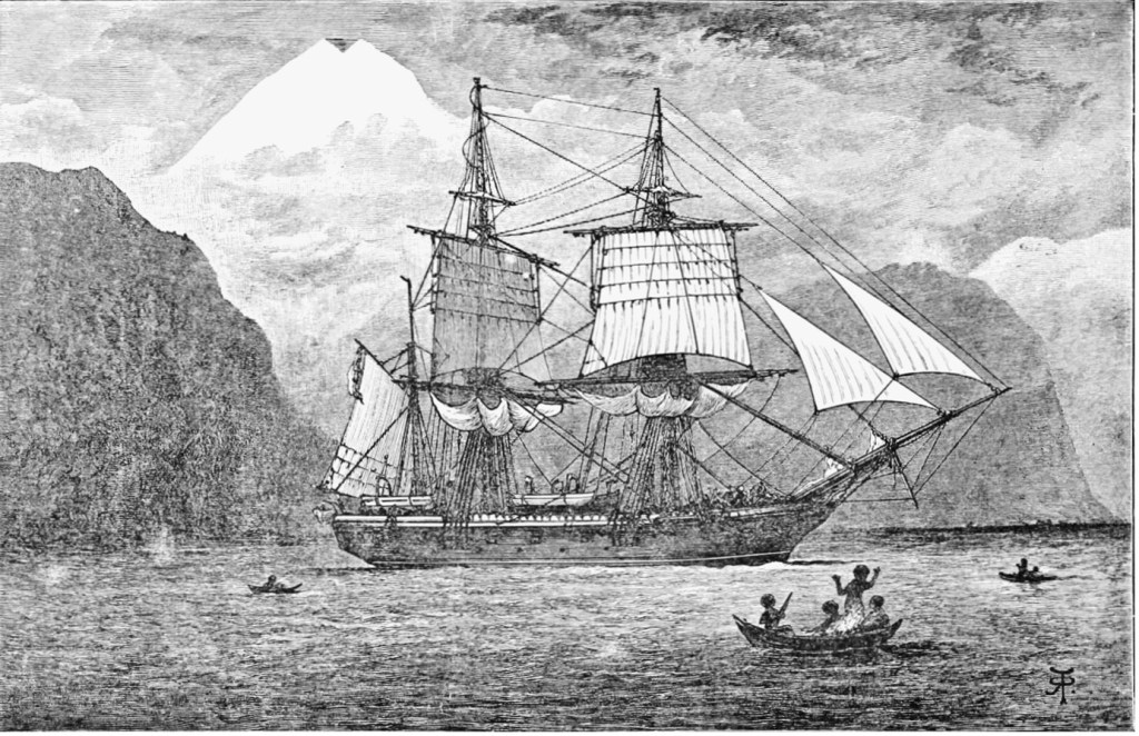
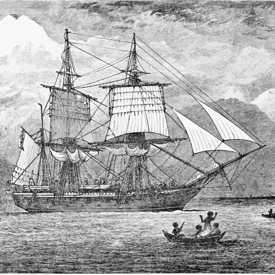
HMS Beagle
First Visit of the HMS Beagle to Port Stephens – 1839
It was on two trips up the eastern coast that the Beagle had occasion to visit Port Stephens.
In May 1839, the Beagle entered Port Stephens to seek shelter from bad weather which would have imperilled the vessel if it had remained at sea. The newspapers of the day gave accounts of this visit. The Australian of 8 June 1839, page 3, reported:
‘The Beagle.— For the first three days this vessel left the port of Sydney she had a nice breeze from the southward, which took her about 100 miles to the northward. Since then, she had nothing but baffling winds with a current setting her to S. E. at the rate of two miles an hour. On the 29th ultimo, in the afternoon, they had a heavy gale, which lasted three days, and upon working up their reckoning they found themselves driven to the southward of Sydney. Upon the gale abating, she tried to fetch this port, but we wind coming foul the only port she could fetch was Port Stephens, where she is now lying, and will probably remain there five or six days in order to regulate their chronometers.’
Crew of the Beagle rescue shipwreck victims at Port Stephens – 1839.
Shortly after arriving in Port Stephens, the crew of the Beagle were required to assist victims of the ship, Francis Freeling, that had also sought refuge in the port. The Sydney Herald of 17 June 1839, page 2, reported:
‘Total Wreck of the Francis Freeling. — Our readers will recollect that this vessel sailed some short time since for Port Phillip, with about forty passengers. It was reported she had three feet of water in her hold, and was obliged to be pumped during her stay in the harbour. She had not proceeded above forty miles, which, in consequence of head winds, took her three days to perform, when a gale of wind sprung up, and from her leaky condition, she was necessarily obliged to put into Newcastle. The pilot there finding he could not render any assistance, from the strong gale that was then raging, advised the captain to proceed immediately to Port Stephens, which he did, and on entering the port, grounded. Immediately upon the accident, every assistance was tendered by the surveying ship Beagle, which was then laying there in consequence of the severity of the weather, and all the passengers placed carefully on shore; in a very short time her cabins began to fill, and before the day was out she went to pieces. One of the passengers arrived in Sydney on Saturday night by the steamer, having orders to charter another vessel to proceed to Port Stephens, and thence to Port Phillip. The remainder of the passengers are comfortably provided with tents, and, we understand, by the exertions of the steward of the vessel, most of their clothes were saved. The highest praise is awarded by the passengers to the officers of the Beagle, for their exertion in rescuing them and also for their kind attention to them on the shore.’
The Sydney Gazette and New South Wales Advertiser of 15 June 1839, page 3, further reported:
‘We have received the following particulars respecting the Francis Freeling, from one of her passengers arrived per steamer Sophia Jane. The Francis Freeling entered the Heads of Port Stephens on Tuesday last, and shortly after struck upon the sand spit, just inside the North Head. She immediately fell over on her beam ends; and H. M. surveying ship Beagle, instantly despatched her boats to her assistance, and succeeded in saving the passengers, who were landed safe at Port Stephens, at which place they would be obliged remain, until the port boat left that port for Raymond Terrace, Hunter’s River, by which conveyance it is expected they will proceed, and come up to Sydney per Tamar steamer, which leaves Newcastle this day. The boats of H. M. ship Beagle, and those of the Australian Agricultural Company were employed saving what portion of the cargo they could get at; but as the vessel was fast going to pieces when our informant left, it was not expected much would be saved. At the time the Tamar saw the Francis Freeling, off Newcastle, Mr. J. T. Wilson, the owner of the former vessel, offered to tow her into Newcastle, but the pilot (Mr. Jackson,) informed him there was too much sea on to attempt it.’
The wreck of the Francis Freeling is found in the paper “A History of 110 Shipwrecks at Port Stephens 1800-1950” at this link on the website.
Commentary by Captain John Lort Stokes
Captain John Lort Stokes was an experienced Royal Navy surveyor and hydrographer who served on HMS Beagle for eighteen years (1825-1843).
After returning to England, he published a book in 1846 entitled “Discoveries in Australia” in two volumes. These were a detailed and valuable account of the coasts and rivers explored and surveyed during the visit of HMS Beagle 1837-1843.
First Visit – May 1839
In Chapter 1.10 of Volume 1: Sydney to Port Essington, Stokes offers the following commentary under the headings:
May 22
‘We again bade farewell to our friends at Sydney, and sailed to explore the north-western part of the continent, which from the number of openings still unexamined, possessed the interest that invariably attaches to whatever is unknown. We submitted, accordingly, with impatience to the delay caused by light north-westerly winds, and a southerly current of nearly a knot per hour, which prevented us from reaching the parallel of Port Macquarie before the 29th; when about forty miles from it we experienced a gale, from North-East and East-North-East, that lasted till the evening of the next day, when we found ourselves about 140 miles South-East of Port Stephens. …… This delay rendered it necessary to obtain a fresh chronometric departure, and as the winds prevented us returning to Port Jackson, we proceeded to Port Stephens, where we anchored, June 5th. We found the Admiralty chart of the coast in the neighbourhood very defective, some islands being completely omitted, whilst others were much misplaced.
Remarkable Headlands of Port Stephens
I have before spoken of the change in the features of this portion of the eastern coast. Here a number of conical hills, from four to six hundred feet in height, suddenly presented themselves to our view, two of them, very remarkable headlands, and preserving the aboriginal names of Yacaaba and Tomaree, constitute the entrance points of Port Stephens. The sea-face of Tomaree is a high line of cliffs, from which projects a sand-spit, leaving a narrow entrance. When in this I noticed that a round hill at the south end of a distant range, was over the opening between the first island and the northern shore of the harbour. Within the entrance are extensive sandbanks, subject to a rapid stream of tide. Port Stephens may be considered a large estuary, about fifteen miles in length, contracted near the centre to a width of about a mile, which is further lessened by the presence of a woody islet, the same I have alluded to. Nearly two miles within this narrow the Beagle anchored off the settlement of the Australian Agricultural Company, a straggling village called Carrington, on the western shore of the harbour.
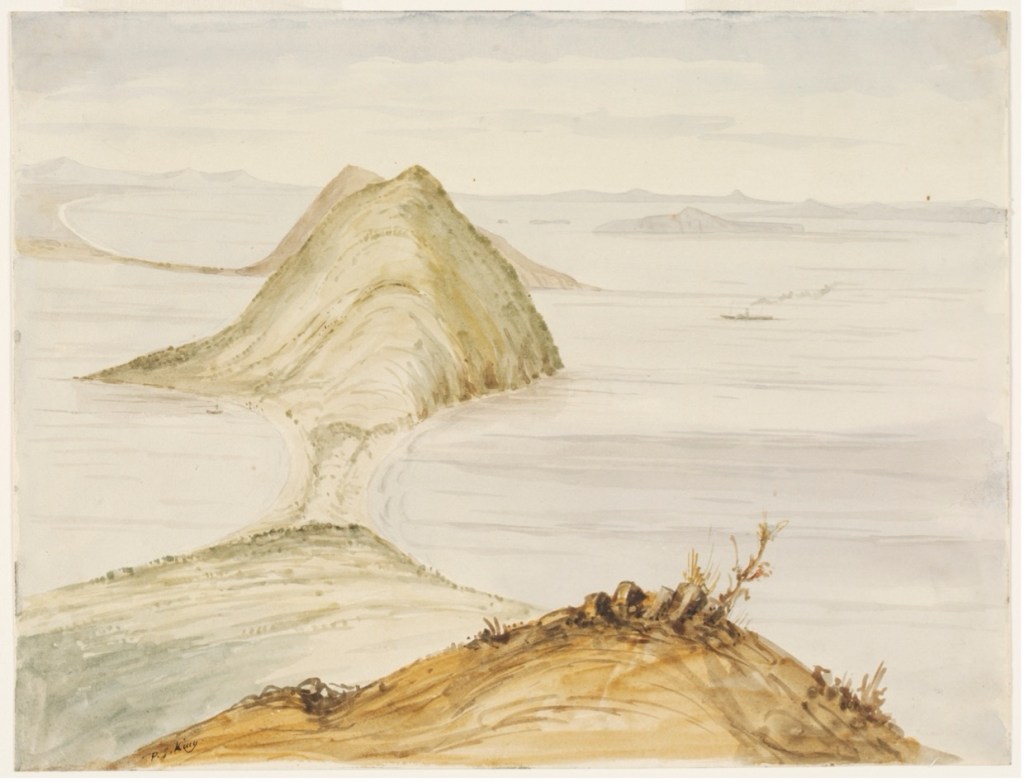
An early illustration of Mount Tomaree, Port Stephens as it likely appeared when the Beagle visited [State Library of NSW]
Tahlee
On the side of a hill, half a mile to the westward, is the residence of the superintendent, a situation which, to enhance the pleasure of our visit, was held by Captain P. P. King, R.N. [captain of the first Beagle expedition]. Tahlee, the name of this spot, surpassed in beauty all I have seen in Australia. It stands on the crest of a steep grassy slope, over which are scattered numerous bushy lemon trees, the deep verdure of their foliage, interspersed with golden fruit, contrasting charmingly with the light green carpet from which they spring. At the foot of this declivity, a screen of trees rising to a considerable height, almost shuts out the view of the water, though breaks here and there allow small patches to be seen, athwart which a native canoe occasionally glides to and from the fishing grounds. These fairy boats, stealing along the water on a fine calm morning, greatly enhance the beauty of the scene. They belong to a party of natives who have taken up their quarters near Tahlee, and who, though by no means a fine race, have always been well disposed towards Europeans. Unfortunately, they are much addicted to the use of ardent spirits, having acquired the habit from the whalers who frequent the place. A young woman and her husband form part of the domestic establishment at Tahlee.
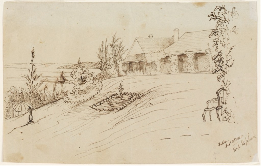
Illustration of Tahlee, February 1840 as it appeared at the time of visit by the Beagle [State Library of NSW]
We were much delighted with the richness of the vegetation, when compared with its dry parched appearance at Sydney – another of the striking characteristic of Australia.
At Captain King’s table I tasted the wonga-wonga pigeon; it is the largest of any of the Australian kinds, and the flesh is very white and rich. It is a difficult bird to shoot, as it always keeps in the thickest foliage, and is strong and quick on the wing.
Through the kindness of the same friend, I was also enabled to enjoy a ride into the country, during the interval between the observations for rating the chronometers.
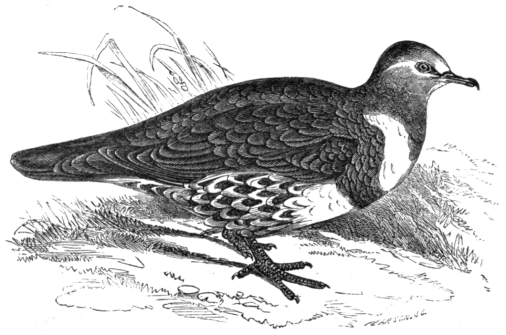
Wonga Wonga Pigeon [Samuel Sidney, Public domain, via Wikimedia Commons]
Karuah River
I had to ascend the Karuah river, flowing into the north-west corner of Port Stephens, for twelve miles to a place called Booral, the furthest point at which is navigable, and where all goods are landed for the Company’s stations up the country. Mr. Ebsworth the treasurer of the Company resided there in a charming cottage, almost covered with roses and honeysuckle, and commanding two picturesque reaches of the Karuah.
About two miles within the entrance, the river bends between high and steep banks, densely covered with creepers and other vegetation of a tropical character, all quite mattered together, and hanging in festoons, the ends of which are immersed in the water.
Trip up the Country
At Mr. White’s hospitable cottage, I met two gentlemen on their way to the Hunter River, and as fortunately the route I proposed taking, lay in that direction, we started together early the next morning. Crossing the Karuah, our road for some distance lay over rugged country, along a winding path between very steep hills. Six miles West-South-West from Stroud, we passed through a range trending North-West from two to three thousand feet high, the debris from which enrich the flats of the Karuah on its eastern, and the Williams River on the western side. ….. [The journey continued through the Stroud and Williams River areas.]
We passed the night at Stroud, and next morning started for Port Stephens. There having been some delay in getting my horse, I was obliged to push over the first seven miles in little more than a quarter of an hour, the postman having waited for me over his time.
On the morning of the 16th we again sailed for the North coast with a fine southerly wind.’
Second Visit – 13 May 1841
Captain Stokes, as commander of the Beagle again visited Port Stephens on 13 May 1841. In Chapter 2.7 of Volume 2, he commented:
Changes on Board the Beagle
During our stay at Sydney some important changes took place among the officers of the ship, the principal of which were the departure for England of Captain Wickham, who had never thoroughly recovered from the attack of dysentery he experienced on our first arrival at Swan River, and the promotion of the writer to the vacancy thus created. Lieutenants Emery and Eden also left for England; the former was succeeded by Lieutenant Graham Gore.
This almost total change in the arrangements of the ship requiring some delay, and the season for passing through Torres Strait, moreover, not having commenced, it was the 3rd of June 1841, before the Beagle again rounded Breaksea Spit, having touched on the way for a meridian distance at Port Stephens.*
(*Footnote. We ran out of Port Stephens before a westerly gale. After passing between Entrance Island and Soldier Point, we steered for Salamander Head, and then for Tomaree Summit, when it was over the centre of the first projection inside Nelson Head, which led over the south-west corner of the shoal patch lying abreast of Red Point in 4 fathoms. When Nelson Head just shut in Yacaaba extreme, we steered for the former, and passing it hauled over North-East 1/2 East for the western part of Yacaaba Head, keeping a white spot on the second point inside Nelson Head, just open of the latter, until the leading marks for running out (which I have before given in my former visit to Port Stephens) were on.)
Singular Corrobory
Whilst at the latter place, I witnessed a corrobory presenting a peculiar feature. As soon as it was dark, a number of heaps of fuel scattered here and there were simultaneously ignited, and the whole surface of the green was speedily lighted up by the flames. When the illumination was complete, the men, painted with spots and lines of white commenced the dance, which consisted in running sideways or in file, stamping with great violence, and emitting an inharmonious grunt, gesticulating violently all the time, and brandishing and striking together their weapons. The peculiar feature in this corrobory, was the throwing of the kiley, or boomerang, lighted at one end; the remarkable flight and extraordinary convolutions of this weapon marked by a bright line of fire, had a singular and startling effect.
Concluding Comments
The third voyage of HMS Beagle concluded in 1843 after its return to England.
In 1845, it was converted to a customs service watch vessel and continued serving as a working ship for a further 25 years. it was eventually dismantled for scrap.
While Charles Darwin did not visit Port Stephens, the Port was privileged to have been host to the historic ship, HMS Beagle.
There was a further local connection with the former Naval Commander, Phillip Parker King, being Commissioner of the Australian Agricultural Company (1839-1849), and residing at Tahlee at the time of the visits of the Beagle.
The Mariners Walk Heritage Trail along the shores of Port Stephens consists of eight detailed signs showcasing some of the maritime history of the area.
The charting of Port Stephens by personnel on board the HMS Beagle is commemorated by Sign No. 8, situated on the shores of Salamander Bay.

Mariners Walk Heritage Trail – Sign MW 08
The signage reads:
‘Whilst there had been many visits by colonial vessels to Port Stephens, very little of the waterway was accurately chartered in the half century or more following its first sighting by Cook on his voyage of 1770. In 1795, Surveyor Charles Grimes traced the harbour and rivers, rowing from point to point and estimating the distances by eye. Governor Lachlan Macquarie on the Lady Nelson passed three days in port over New Year 1811-1812 whilst looking for a new convict settlement, however no charts or sketches were left. Henry Thomas Ebsworth and John Armstrong (1826) and Henry Dangar (1828) made their additional marks, and various timber-getters and ships used the port thereafter, but still the charts were very few and incomplete.
It was only after the Australian Agricultural Company was established that suitable surveys were undertaken. Dangar’s survey had given much more detail of the shoreline and hinterland but not of the waterway.
This was further enhanced by the work in June 1839 of Lieutenant John Lort Stokes, Surveyor of the HMS Beagle, which had just a few years prior carried Charles Darwin on the voyage on which he made his name. Eventually the chart was completed in 1845 by Captain Philip King, Commissioner of the Australian Agricultural Company, and this survey was published by the Admiralty in 1847. These charts were again developed by Lord Jellicoe for the naval base in 1911.’
It is noted that a copy of Grimes’s early chart is still extant and can be found at the link First Land Survey and Early Maps of Port Stephens on this website.
An additional Port Stephens Survey Map was published on 3 May 1924 at the Admiralty in London. It was compiled from the survey of Port Stephens undertaken by Commander (Acting) C. M. L. Scott, Royal Navy, from April to August 1920, in H.M. Surveying Ship Fantome. Further information can be found at the link Port Stephens Survey Map -1920 on this website.
POSTSCRIPT
Third Voyage of Discovery by HMS Beagle to Australia.
A comprehensive article on the third voyage of HMS Beagle was written by Phillip Parker King. It was published in the Sydney Morning Herald of 10 February 1843, page 2, and summarised the extensive and valuable survey work undertaken in the Western Australia, South Australia, Bass Strait and Torres Strait regions:
‘The voyage of Her Majesty’s Surveying Vessel Beagle having been completed, it may not be uninteresting to the readers of this journal to be informed of the result of the work that has been performed by the tenants of her wooden walls since her arrival from England, in the year 1837.
The objects of her voyage were not confined to one spot or portion of the coast, but, generally, to complete all parts that had hitherto escaped the notice of, or had not been visited by, previous navigators: particularly, portions of the north-western coast which were not seen by Captains Flinders and King, or by the French expedition under Commodore Baudin, in the year 1802.
The Beagle left England originally under the command of Captain J. C. Wickham. This officer, however, after two harassing voyages to the north-west coast in which several interesting points were established, and two rivers (the Adelaide and the Victoria) discovered was necessitated to return to England, on account of bad health, brought on by the extreme heat of the climate, when the command devolved upon Captain J. L. Stokes, who has completed the objects of her voyage, and now takes her home to receive, it is hoped, the reward of his long and useful services.
To describe the work performed, in the succession in which it was executed, would be out of place here. It is better, therefore, to give a general summary of the different portions of the survey in the order, as to position, in which they follow each other.
Commencing, therefore, with the eastern coast. The inner route towards Torres Strait was twice navigated on the way to the north coast, and several important corrections and additions made to the charts now in use. Of the latter may be mentioned, the determination of a better outlet than the one to the north of Wednesday and Hammond Islands, viz., by passing through Endeavour Strait, which hitherto has been considered to be too shoal for vessels of large burthen. Captain Stokes has however ascertained, that by keeping nearer to Wallis’ Isles, a good channel or outlet exists in which there is not less than five fathoms water. The passage, therefore, through this part of Torres Strait has been very much improved.
The next important feature of the Beagle’s voyage, was the discovery of two considerable rivers at the bottom of the Gulf of Carpentaria, flowing through a fine country in a south-westerly direction for sixty miles, navigable for thirteen miles for vessels of thirteen feet draft, and to within five miles of where the water is fresh; the boats, however, traced it for nearly fifty miles further, to the latitude of 17 ° 59′ and longitude 139 ° 30′. The climate was found, in the month of August, to be of an agreeable character, the thermometer in the month of August indicating an average temperature of 60.9, the minimum being 50°. To these rivers the names of “Albert” and “Flinders” were given. The character of the country is low, and the soil chiefly alluvial. No satisfactory reason has been given for the low temperature of this tropical region, which, as the latitude is about 17°, ought to have been at least 70° or 75 °. The situation of these rivers may at no distant period open a road to the interior, which is at present wrapped up in doubt and mystery.
The next discovery in succession to the west, was that of the Adelaide River, at the north-west part of the Gulf of Van Diemen, similar in character to the Alligator Rivers, which were discovered in the year 1818, falling into the gulf at its southern part. Proceeding farther, another river was found of more importance, as to size, than any previously known in inter-tropical Australia. It was called the “Victoria.” It extends for about one hundred and fifty miles to the S.E. by E. and is navigable for vessels of burthen for sixty miles from the entrance: its further examination was made by a pedestrian party to the latitude of 15° 30′ and longitude 130 ° 52′, and was left still flowing from the south-east. This position is about five hundred miles from the centre of the continent. The character of the river may better be understood from the following extract from Captain Stokes’ journal: “The valley through which the river passes varies in its nature, from treeless, stony plains, to rich alluvial flats, lightly timbered with a white-stemmed gum; the banks are steep and high, thickly clothed with the Acacia, drooping Eucalyptus, and tall reeds. There was no perceptible stream in the upper reaches; but, if we may judge from the inclination of the stems of the trees growing in the bed, and heaps of large boulders in the channel of the river; the Victoria, at some recent period, must have been a large and rapid river.”
Whilst employed in making observations at Cape Pearce, which forms the north entrance of this river, Captain Stokes was treacherously speared by the natives, the wound was a severe one; but assistance being rendered, his life was happily saved. It is a curious coincidence that the three officers whose services as surveyors in the late expedition have been most prominent, viz. : Captain Stokes, Mr. A. B. Usborne, master, and Mr. Fitzmaurice, mate; each met with serious wounds in the prosecution of their duty, Messrs. Usborne and Fitzmaurice, from muskets accidentally exploding: the former was obliged to invalid in consequence, and the latter, who however has persevered to the last, will be lame for life.
The rivers Albert and Flinders to the eastward, and that of Victoria to the westward, converge in the direction of their sources apparently to one common point; to which also do the intermediate rivers — the Alligators and the Adelaide. It seems probable that all derive their origin from some large inland marsh or lake, to which they serve as drains. It is not unlikely that there may be a low tract of land between the Gulf of Carpentaria and the Great Horseshoe Swamp, found by Mr. Eyre in the northern part of the province of South Australia.
With respect, however, to the climate of the country in the neighbourhood of the Victoria, the temperature, ranging between 93° and 110 °, was found by the Beagle’s officers in the month of November to be almost insufferable, and quite different to that experienced at the Albert, in the Gulf of Carpentaria. It would seem from Captain Stokes’ description above inserted, to resemble in character the country about Cambridge Gulf, which has its embouchure to the sea, a short distance to the westward.
The next part of the north-west coast visited by the Beagle, was the opening that was supposed to exist at the back of the Buccaneer’s Archipelago. Perhaps no part of the whole coast promised to be of greater interest and raised hopes of the existence there of a large river, hopes that were justified by the great rise and fall of the tides, which exceeded thirty-six feet. It was, however, found to be but a comparatively unimportant indentation, the eastern part or Collier’s Bay being nothing more than a shallow sinuosity of the coastline, and the western part narrowed gradually into a tolerably extensive sound, terminated by Fitzroy River, which was traced for twenty-five miles in a southerly direction, draining the lowland from and through which it flowed. The opening near Cape Latouche-Treville, which was thought also to be another outlet of the supposed river, or else the mouth of a second, was an open bay not affording even sheltered anchorage. The interval between this part and Depuch Island, was also explored, but not found to contain any inlet or feature of importance. It is generally a sandy and low sterile coast, fronted by a shoal approach and several sandbanks, the positions of which were ascertained. The Monte-Bello Islands were also correctly and minutely surveyed, as also some rocks in the neighbourhood, which are doubtless the Trial Rocks of former navigators.
On the west coast, the Houtman’s Abrolhos was also explored and surveyed, together with the coast within it, where the fertile appearance of the coast gave strong indications of the presence of a country favourable for settling. It is here that Governor Grey recommended the Australind Company to establish themselves. Fortunately, however, they had located themselves at the inlet called Port Leschenault: for they afterwards ascertained that the former would not have suited their wants. Several new anchorages about Rottnest and Gage’s Road, off Swan River, were also examined and surveyed, in which much advantage will be derived by the colonists at Western Australia.
South Australia has also had the advantage of the Beagle’s services in the survey of the anchorage and port at Adelaide.
But perhaps the most important – because useful – work performed by the Beagle has been the detailed survey of Bass’ Strait, which has been just completed by Captain Stokes, with the aid of the Government of Van Diemen’s Land ; which, in the most liberal way, at once acceded to the request of Captain Stokes, by devoting to his services the use of the colonial cutter Vansittart, for the survey of the southern portion of the eastern entrance of the Strait. The command of the vessel was temporarily given to Mr. C. C. Forsyth, mate of the Beagle.
The result of these labours has been the completion of the survey, in which the proper and relative position of the various headlands, capes, and islands, which are so prominent and numerous in the Strait, are laid down; with the tides, soundings, and description of several new anchorages, in a manner that cannot but be of immense importance to the commercial interests of the colony. Much important information, relative to the entrance of Port Dalrymple, as well as that of Port Phillip, and the channel within it, the approaches to and anchorages to the southward of Corner Inlet have also been furnished by the operations of the Beagle during this important survey. Much labour and personal exertion have been bestowed upon this work, and too much praise cannot be given to those who have been prominent therein. It may be, however, necessary to say, that it was commenced by Captain Wickham, and completed by Captain Stokes.
This, however, would not have been the last work which the Beagle would have performed for the colony, but for obstacles which unexpectedly presented themselves, and prevented Captain Stokes from making a survey of the neighbouring coasts of Port Jackson. The necessity for a chart of the coast is very urgent, from discrepancies which have been found to exist in the only chart now in use, and the principal materials for it have been from time to time prepared as the Beagle passed up and down the coast. It is to be lamented that this desirable matter could not have been accomplished.
It is unnecessary to follow the Beagle with more detail through her various movements upon the long and tedious service upon which she has been employed. Suffice to say, that the fruit of her voyage has been of the greatest importance to the navigation of the coasts, which will be amply proved when the charts of her voyage, particularly that of Bass’ Straits, are published, and placed within the reach of navigators, by whom alone, from the unpretending manner in which the work has been performed, it can be estimated as it deserves.’
Researched and compiled by Kevin McGuinness
June 2023
