
Introduction
James R. Fulton was the secretary of the Underbank Branch of the Farmers and Settlers’ Association in 1914, in the Dungog district. He was a strong supporter of decentralisation of economic activity away from Sydney, so that regional areas could enjoy a greater share. He was an advocate for the development of Port Stephens as an overseas port for the export of goods from the north and north-western areas of New South Wales.
Following on from the 1911 Royal Commission as to Decentralisation of Railway Transit, James Fulton and his wife undertook a tour of the Port Stephens region. It was partly for pleasure but also to investigate the economic prospects of the area.
Fulton wrote three articles documenting his trip. which They were variously published in The Land journal in June 1914. They are very descriptive and illustrate his grasp of the local economic issues. The three articles are set out below.
Article One – Published in The Land, 12 June 1914, page 6:
‘Having written several letters on the subject of Port Stephens derived chiefly from evidence given before the Royal Commission for Decentralisation, I determined to take the first opportunity of paying a visit to that interesting and much discussed locality to better learn from first-hand how far what I had read was confirmed by sight. As a hurried description may find something of interest to your readers, I send along some account of my trip.
To Karuah
Mrs. Fulton and I left home [Dungog area] early in the morning of Tuesday, the 15th inst., and with a brief rest at Clarence Town, drove to Karuah, sometimes known as Sawyer’s Point, at the mouth of the Karuah River. The distance to this spot from our starting point would be about 45 miles. The country to Clarence Town is too well known to need describing. From Clarence Town to Karuah the country is of a marked inferior character, and as you near Karuah does not improve, but small holdings along this distance show a praiseworthy effort to cope with the timber and under-growth, and when cleared the grass appears fairly good, and capable of improvement. This was more noticeable about Karuah, where it was more open, while on the further side of the river some 85 sheep belonging to Mr. Johnston showed a condition of fleece and carcase that could only be the result of succulent grasses.
Grass Trees
The whole of this part of the country, and as far as I saw it to Allworth, seems to be covered with a small grass tree, thousands of them. If it is a fact that a good varnish is obtainable from the grass tree stems, and these contain it, surely some commercial benefit could be derived from that source. The first peep of the river gave the promise of a considerable expanse of water, which was confirmed on closer approach. The river shows a breadth of 200 yards, with a very considerable depth. At this spot it is crossed by a free punt, near which is a jetty, utilised by the steamers and fishing craft. The township of Karuah is a small one.
Karuah
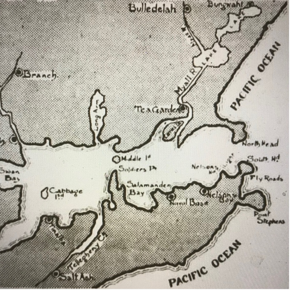
On the south bank is the public school and teacher’s residence, from which a beautiful view of the inner harbour and the higher reaches of the river is obtained. The teacher is Mr. Archer, who is also the secretary of the Karuah Railway League. I had the pleasure of inspecting the school during school hours and the children’s drill, and was much impressed with the utility of the drill, and the practical methods of instruction, as well as the general healthy look of the youngsters. I saw, also, a very well executed piece of hand carving by a boy whose name I regret I have forgotten. I am also in debted to Mr. Archer for a rough sketch (see below) of the port, which was most helpful, and which I enclose, for though it was roughed out in a few minutes, without even reference to a copy, it is sufficiently accurate to grasp the lay of the country.
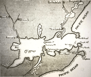
Rough sketch of the various locations visited by James Fulton on his Port Stephens tour – 1914
In a sheltered nook, with a frontage to the river and overlooking the inner harbour, is the substantial and comfortable looking residence of Mr. Longworth, with its tastily laid out grounds, quite an ornament to the locality. Further in the background are the church, small stores, accommodation house, some fishermen’s cottages, and a small colony of blacks and grades. From here the river opens out considerably (looking to its source) to about a mile or more at high water, and here several neat motor launches were riding easily at their moorings, conspicuous among them being a large steam launch belonging to Mr. Longworth.
The Inner Harbour
On the harbour side the river may be said to end at Karuah, as it widens out to a great distance, the expanse being lost in the blue haze. From a small hill near by the picture is an enchanting one. The water opens out on the south side first in a deep bay called Swan Bay, further to Pipe Clay Creek, Tinalba [Tanilba] Point, Tilligerry Creek, and on to Soldier’s Point, with Cabbage Tree Island halfway, while on the northern side it stretches past the late Hon. White’s pretty residence and grounds to Carrington, North Arm, and Fame Cove, opposite Soldier’s Point, with Middle Island in the centre. This forms the inner harbour. More of this anon.
On the north side of the river are the residences of Mr. Johnston and Mr. Simms. The latter is on the site of the sawmill, from which Sawyer’s Point got its name. Mr. Johnston has charge of the punt, and Mrs. Johnston keeps the local post office and telephone. We were comfortably housed by them, and on the following day, about 11 a.m., on the arrival of the s.s. Karuah from Sydney, we embarked and took our passage up the river to Allworth, some 12 miles upstream.
The s.s. Karuah (Capt. Phillipson) is a comfortable passenger steamer, both trim and well appointed, drawing between eight and nine feet of water. The river, notwithstanding its great width at high water above Karuah, has only its proper channel, and requires careful navigation. The river trip, though delightful, cannot boast of much scene beauty, much of the land being low, and apparently poor and heavily timbered. Logs for milling purposes were much in evidence, and a few farms, some showing considerable labour had been expended in clearing. We drew to the wharf at Allworth, where the steamer made fast for the rest of the day and night, and discharged her cargo into a large shed on the wharf, and took, aboard a considerable amount of sawn timber.
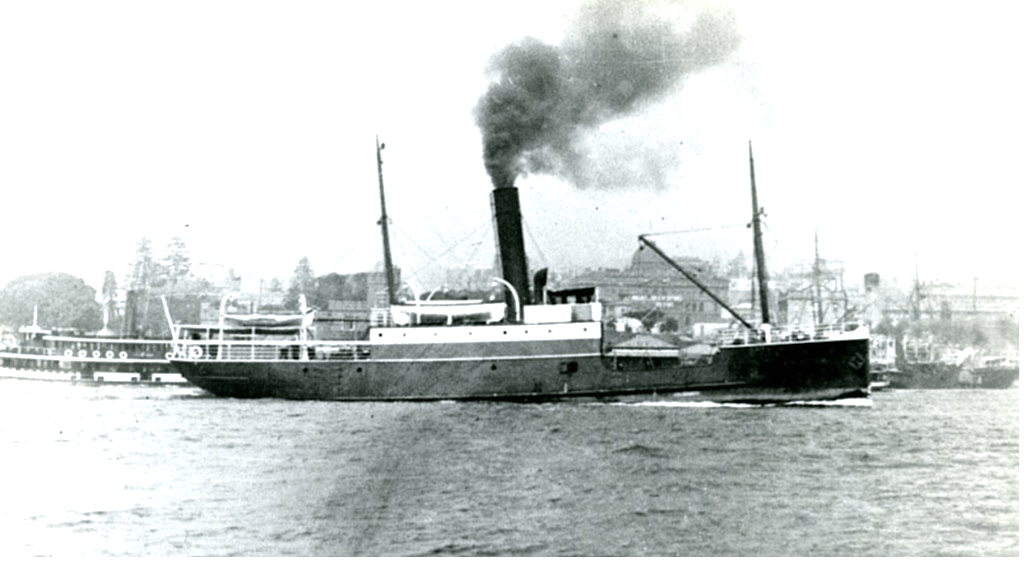
ss Karuah
Timber Industry
We went ashore and toured the locality, visiting two sawmills, one belonging to the Karuah Sawmill Co. and the other to Armstrong and Royse. The larger Jarrah Company’s sawmill was too distant, but one of their large traction engines delivered a heavy load of timber while we were there.
Until a railroad does that work such engines of destruction make shire roads impassable. This settlement consisted of a public school, Methodist Church, accommodation house (introduced to me by our skipper as the Hotel Cecil), and many cottages of those working in connection with the adjacent sawmills. A neat little dairy farm occupied an island opposite.’
Article Two – Published in The Land, 19 June 1914, page 3:
‘At 7 o’clock the next morning we were again under weigh, and made the return call at Karuah, where the first of the fishing boats came alongside. From this on, boat loads of fish arrived, to be emptied by baskets into boxes in the steamer’s cool chambers. Leaving Karuah and taking a shorter but seldom used and difficult channel, with a fast-falling tide, we touched the shoal, and the hawser carrying away, had to exercise our patience for the returning tide. With ample time for observation, I have photographed on my mind an oyster lease nearby with a pigeon-house erected on four legs by the enterprising owner, who arrived with his mate and swarmed up a sloping pole into the cubby house, with his bare hands and feet ……
About mid-day the steamer Myall River (Captain Saddler), a flat-bilged boat drawing 3 or 4 feet of water, drew alongside to unload palings. Several fishermen’s boats were in tow laden with fish. Some boats we counted had 17 large baskets full of fine fish. Sea mullet, netted outside, some 18 inches long; fine fat jewfish two feet and more long. One of the ship’s company vouchsafed me the information that these jewfish when cooked in Sydney are better known as schnapper, and much appreciated; very fine flathead were there, tailers, leatherjackets, flounders, bream, garfish, and later on a fine black kingfish that turned the scale at 75lbs.
A huge box in one boat was uncovered and exposed lying on ice a lovely lot of fine pink schnapper. How all this cargo of fish disappeared in the steamer’s cold chambers was a marvel, but one evening the bunkers were full, and ice failing, a boat load had to disappear over the side. It seems a pity. Surely there is room for a salting and smoking business here. Fish now are extra plentiful—a glut. Who gains? Not the fisherman. Co-operation here is badly wanted. Someday it will be. The harbour swarms with fish: they swarm outside the heads; the rivers are full of them; the lakes also. Oysters too. All the foreshores, from the harbour entrance 30 miles away to Allworth, 30 miles up the Myall Lakes; in the bays in North Arm and Farm Cove, away out on the sandy shoals, oyster leases everywhere. Each applicant must apply for not less than 500 ft.; after that he may apply for lesser additional areas. Think of the distance, the double frontage, the indented foreshores. What a host of leases. What a revenue from this source, and yet a neglected port. The money absorbed elsewhere. It is not pleasant thinking.
Tea Gardens
Afloat once more we steamed past Middle Island into the outer or main port, and from there to Nelson’s Bay, when daylight failed. We left the “Karuah” there, still absorbing fish, and steamed away in the Myall River steamer across the harbour, up the Myall River to Tea Gardens, arriving about 8 p.m. There is a good hotel here, and also a boarding-house well kept by Mrs. Engel, both of which are worthy of patron age and moderate in their charges. Two sawmills, stores, some neatly built cottages, English Church, and several jetties form a neat little township, with a wide esplanade planted with shady Moreton Bay figs. The only fly in the ointment is the police station. It is a positive disgrace …… You could grow mustard and cress on the damp-rotting shingles. One member should photograph it and hand it to the Minister for Justice, with Tea Gardens compliments. For those who enjoy boating and fishing I have not struck a better little spot for a quiet rural holiday than Tea Gardens. Motor launches and boats are on hire and will take you anywhere.’
Article Three – Published in The Land, 26 June 1914, page 7:
‘The following morning, we were again seated in the “Unity” launch and gliding along rapidly from the river. Passing Corrie Island at the entrance of the river, where Messrs Allen Taylor & Co. have a large depot for their logs, and I am informed are likely to open a sawmill, we passed it on our right and took the left and rather narrow channel, rounding a sandy point to our left and working between this and a shoal, with broken water on our right, we headed for the North Head. After passing the shoal we were in very deep water, which we kept all the way to Nelson’s Bay.
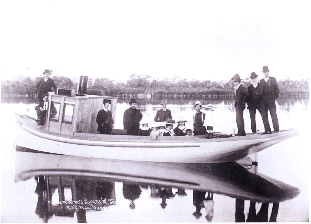
‘Unity’ launch which was built in 1905
The North and South Heads are two bold headlands, rocky and deep to the water’s edge, with about 4200ft. between them. It is a noble entrance, having inside Shoal Bay and Nelson’s Head on the left, the latter with a beacon light on it. We passed within half a mile of this, and entered Nelson’s Bay, capable of holding considerable shipping. The range there is not severe, though so near the heads. We landed for letters. Houses are dotted up the embankment off the beach, among which is a good well-built hotel and a very comfortable looking boarding-house of two storeys, kept by Mrs. Lund. At the jetty were several boats loaded to the gunwales with a variety of fresh fish just caught, the sea mullet predominating. Several pretty launches were riding at anchor here, a large model private launch belonging to Mr. Barry Cotter being especially noticeable.
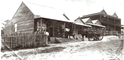
Mrs Lund’s two storey boarding house (top of the hill) at Nelson Bay
Salamander Bay
From here we kept the coastline on our left, all very deep water passing several little nooks and the naval base, in a well-sheltered bay, and rounding a point reached Salamander Bay, five miles from the Heads. This bay is the daddy of them all, containing some four-square miles of deep water, and splendidly sheltered. It has a white sandy beach which rapidly deepens.
It is to be hoped the Government will not sell an acre of this foreshore or the background, for it is is a most valuable asset to the State, and it cannot be long before it will be requisitioned for State purposes. On the west side is Buff Head, with, deep water to its foot. A sheltered nook lies next, and beyond is Soldier’s Point, which forms the southern point of an inner harbour. Near this is an aboriginal camp, with their houses, nets, and fish boats. They are well spoken of as a steady, sober lot, very handy, making their own dwellings and boats, and I was informed a skiff made by one of them competed and won a prize in Sydney.
Buladelah
A 12-mile run up this part of the river brought us to Buladelah township at the jetty below the bridge which spans the river. We could only delay to take a snapshot of the Alum Mountain a remarkably rugged and somewhat precipitous upheaval that rises abruptly beside the town. This unique mountain is rich in alum and other minerals, and sufficiently so to be quarried by a company and shipped to Port Stephens, and thence overseas. We passed through the town, where we noticed several stores, two hotels, post and telegraph office, a butter factory, and a most substantially and well-built courthouse.
Time being precious, we again embarked and ran swiftly down the river, passing the Myall River steamer in the first lake on her way to Bulahdelah. We re-entered the lower end of the river and returned to Tea Gardens, our skipper having to run some eight miles in the dark, with a drizzling rain, but he seemed as comfortably at home along the river’s tortuous course in the dark with a drizzling rain as in sunshine, and we landed from quite a 70 miles’ run without mishap or one unpleasant happening.
Thurlow’s Ferry and Coach Service
That evening, I had a chat with Mr. Thurlow, one of the enterprising residents. This gentleman has a through service from Stockton (Newcastle) to Salt Ash, on the Tilligerry Creek, by coach, and from there by motor launch to Nelson’s Bay and Tea Gardens. The through fare is 7/— a cheap and as pleasant and healthful a holiday trip as townspeople could desire. I am indebted to Mr. Thurlow for some good photos of river scenes and interesting parts of the port, which I hope to make good use of by and by.
Fame Cove, Middle Island and Pindimar
Rounding Soldier’s Point, we steered a southerly course, until we could see the entrance to Tilligerry Creek, which runs many miles in land. Eight miles up this creek is Salt Ash, before spoken of. We turned then northerly, entering Fame Cove, on the northern side of the harbour, a useful, sheltered cove with deep water. The prospective town of Pindimar is surveyed on the east of this cove, and cut up into allotments, many of which are sold.
Between Fame Cove and Soldier’s Point is a rocky wooded islet, called Middle Island. It has deep water all round, and in conjunction with Fame Cove and Soldier’s Point forms the entrance into the inner harbour. In the present natural state this gives an additional harbour of a half square miles.
After visiting Fame Cove we ran the coast westerly to North Arm. This is a small harbour in itself, with deep water and sheltered from all winds. The entrance would be nearly half a mile wide, widening out inside to over a mile, and then drawing in, making perhaps two miles in length. A long, low, clear ridge on the northwest side would be a very suitable spot for a town. When Port Stephens comes into its own this spot should be the terminus of a railway line from Stroud road and is so recommended by the Royal Commission [which published a report in 1911].
Tanilba Point and Pipeclay Creek
After taking a snapshot in North Arm, we took a south-westerly course towards Tanilba Point and Pipeclay Creek. The former has a massive stone house built upon it in the convict days. The latter creek towards the entrance is wide but shoally. Pure pipeclay is found up this creek, and bricks were at one time made. We passed through deep water all the way. Entering the proper channel to Karuah, we skirted Cabbage Island on our left, and after weathering the further most point of the island headed for and entered Swan Bay. This is an extensive bay, but very much silted up with sandy shoals, the latter marked out into oyster leases. We lay-to here and had our lunch and watched the hundreds of black swans which had possession of this bay bearing their name.
After taking a snapshot of the sandy beach and houses we returned to the channel and got a fairly straight course for the Karuah River, which was soon reached, and ended our short but very pleasant and instructive pleasure trip to Port Stephens. The water, I should have mentioned, was smooth and glassy all around us, the porpoises lazily somersaulting after each other. In places the surface of the water was rippled with shoals of fish, and occasionally the rush of the “tailers” among them would raise a spray of two or three feet above the escaping fish, while the gulls above, watching their opportunity, would dart down for their share. Two turtles with backs 4ft. or 5ft. long rose and fell near us on the swell, their uncanny, snake-like heads obtruding for a short space, and then with their flat bodies disappearing without a ripple.
Second Only to Port Jackson
So far for pleasure, but before closing I crave space to say something of the Port, viewed from a national standpoint. We have here a port which, though in its natural state, almost, unaided and uncared for, can only be placed second to Port Jackson, and given the same outlay, would be a larger and more efficient port. The best expert evidence states £330,000 will make this a fully equipped port, with lights, buoys, wharves, two coal hoists, and railway compound, capable of harbouring the largest oversea vessels. Another similar sum would connect it by railway with the Northern railway line. This done, the whole of the north-west could utilise this port as easily and cheaply as Newcastle, without accumulation or congestion, and with the advantage of loading far larger vessels. …..’
Concluding Comments
Information on other early travel excursions throughout the Port Stephens district are published on this website and can be viewed at the following links:
The Lakes Travel Route to Mid-North Coast
A Four Day Excursion to Port Stephens – Christmas 1906
Excursion from Newcastle to Port Stephens by Sea
A Journey from Port Stephens Up the Myall Lakes to Forster – 1908
Journey from Maitland to Port Stephens – 1889
An excursion to Port Stephens by Dr Richard Arthur, MLA – 1914
‘Dungog and Round About’ – 1909 and 1910
A Description of Nelson Bay – Port Stephens – 1892
A Vacation Cruise from Sydney to the Myall Lakes – 1892
A Journey Around Port Stephens – 1894
Researched and compiled by Kevin McGuinness
October 2022
